
Abstract
Changes in travel behavior for commuters living in the suburbs have a lot of disadvantages and consequences, such as unsafe travel behavior. This paper reviews the literature on the connection between roadway safety and travel behavior on the suburban highway networks. Through a systematic synthesis of peer-reviewed studies, this review evaluates key exposure variables including transportation mode, road conditions, traffic conditions, land use patterns, socio-economic factors, and trip attributes. This review analyzes the resilience of reflective indicators of safe travel behavior. Evidence shows that low-density urban forms increase dependence on motorcycles, travel distances, congestion, and accident severity. These insights inform suburban planning and the design of safety-oriented policies.
Keywords: blackspot, land use, road accident, safety travel behavior, suburbs
Outline
1. Introduction
The expansion of urban areas into suburbs is a global phenomenon. The director of the Tennessee Valley Authority, Earl Draper, used the term "sprawl" in 1937 to refer to unsightly and unprofitable settlement types1). Several decades later, William H. Whyte Jr. established the phrase "urban sprawl" in urban planning discourse with the seminal essay in Fortune magazine, which was subsequently published in The Exploding Metropolis2).
The rapid expansion of residential areas in the suburbs is commonly associated with urban sprawl. This phenomenon creates a spatial disconnect between where people live and work, leading to transportation problems with high dependence on private vehicles3,4), low population density in new settlements, uneconomical infrastructure and public service provision rural depopulation5), fuel energy waste6), and high maintenance costs7) for road networks connecting suburbs to the city center, reduces service efficiency as public transit, emergency services, and waste management become more expensive and less effective8) and finally the spatial separation between housing, employment, and activity spaces leads to longer commuting distances, with disparities shaped by socioeconomic characteristics and land use patterns9).
Road network expansion is a major driver of urban sprawl in both developed and developing countries. Empirical evidence shows that new and expanded road corridors stimulate residential growth, population increases, and rising numbers of housing units across numerous cities10). In European contexts, road provision has been associated with large-scale suburbanization11). Similarly, extensive road networks in low-density areas influence traffic volumes and the performance of these networks, depending on transportation distribution and planning priorities12). Even in regions with well-established public transport, road expansion continues to shape metropolitan spatial form13).
A different condition occurs in developing countries. The phenomenon is a lack of infrastructure, public facilities, and basic services, accompanied by little or no public transport and inadequate road access14); with low densities in peri-urban areas, agricultural and arable land turns into housing, and public facilities are scattered, as a result, the provision of infrastructure and utilities in these areas becomes expensive15,16) which results in high fiscal costs for infrastructure and health problems17).
As in other developing countries, residential development in the suburbs of Indonesia has different characteristics. Most major cities in Indonesia experience the phenomenon due to several factors, most notably the improvement of the road network that tends to extend into the suburbs, such as the Jakarta Metropolitan Area (JMA). The improvement of the road network over the past three decades has resulted in economic and land use development. It has increased industrial areas and residential areas in the suburbs18,19), and the transformation of rural land into new cities in the periphery of Jakarta, with the development of the road network20,21), settlements, and business developments occurring along the road to the city center22). This phenomenon also occurs in Surabaya City where a large share of the population lives in the suburbs23,24), as illustrated by Normalized Difference Built-Up Index (NDBI) indicating a 43.95% conversion of non-built-up to built-up area between 2002 and 2018 due to the urban area widening25), most of whom travel daily to work in the city center, economic growth and settlement development in the suburbs have a significant impact on mobility characterized by traffic congestion caused by the increasing number of motorcycles and private cars26).
Motorcycles have become the dominant mode of transport in Indonesia, particularly in big cities such as Surabaya27). This condition is also due to the lack of public transport facilities available in suburban areas28). Beyond its effects on mobility, the fast suburbanization process has wider environmental costs. It contributes to rising energy consumption in Indonesian cities, including Surabaya29). More critically for this review, motorcycle dependence combined with dispersed suburban development intensifies exposure to road safety risks on suburban networks.
Changes in travel behavior occur due to several factors from the commuter background, for example, socio-economic factors, as well as perceptions and travel behavior related to regional expansion in two Iranian cities30), the main daily activity, number of non-commuting trips, mode choice for non-commuting, choice of residential location as well as monthly income, length of stay in the current home in the suburbs, and travel distance affects travel behavior and travel satisfaction with transportation modes and trip duration with differences in residential location and location of main activities outside the home31), the impact of the spread of growth centers from the center to the periphery affects accessibility, availability of new public services, developer initiatives, and physical characteristics of the area, and causes social transformation in local communities as occurred in the Jalan Tun Abdul Razak Corridor, Makassar, Indonesia32).
Land use change occurs significantly with low density on all sides of the periphery. The commuters from this area cause traffic congestion on the highway network, which is the entrance to the city center, due to changes in the travel behavior of residents who mostly use private vehicles33). Similar dynamics have been documented in the Jakarta Metropolitan Area, where land use change in the urban fringe of Bekasi City progressively intensified transport complexity and commuter dependence on private vehicles34).
Changes in travel behavior will lead to an increase in accidents. Existing research has not sufficiently provided integrated empirical evidence that directly explains the impact of urban sprawl on accidents, focusing on motorcyclists as accident victims. Traffic accidents are a threat to society and a significant source of disability in both developing35-37).and developed countries38-39).
Currently, urban sprawl will increase trip generation and attraction to/from residential areas in the suburbs which will also grow vehicle ownership, dependency on motor vehicles, vehicle miles traveled (VMT), travel time, congestion, and accident rates40), and lead to a trend towards the use of private vehicles41) especially motorcycles27) due to inadequate public transportation facilities in suburban areas42). This condition is because most commuters live in lower population density areas and work in higher-density city center areas43). This situation will also increase the number of minor and severe crashes that occur in urban areas, while fatal crashes are more common in suburban areas44).
Several literature reviews have partially addressed the intersection of traffic safety and travel behavior, yet each covers only fragments of the problem examined in this paper. A review of crash density and suburbanization in the Chengdu urban area, China, established the spatial association between urban expansion and crash concentration but focused on environmental factors involving predominantly four-wheeled vehicles, without addressing commuter behavioral responses45). A review of urban design factors influencing traffic crashes systematically categorized determinants into land use, complementary buildings, road equipment, and landscaping, but treated crashes solely as outcomes of physical design, overlooking the socioeconomic characteristics of road users and their behavioral adaptations46). A review of factors associated with safe driving behavior comprehensively mapped social, economic, physical, environmental, and human determinants, but was conducted predominantly within car-oriented, high-income country contexts and did not examine how crash experience itself reshapes subsequent travel behavior47). Meanwhile, reviews addressing road safety in developing countries have mostly concentrated on infrastructure deficits and resource allocation, such as road48-51), and driving conditions52-53), without integrating these structural constraints into a safe behavioral framework.
As a result, the current review literature fails to address four gaps. First and foremost, no previous review has systematically incorporated exposure variables such as socioeconomic characteristics, travel characteristics, transport modes, road conditions, traffic conditions, and land use patterns with crash experiences and safe travel behavior within a single conceptual framework. Second, suburban road networks, the nexus of land use transformation, commute intensity, and infrastructure deficiencies have not received much attention in the present evaluations, which have mostly concentrated on urban cores. Third, commuters' behavioral responses comprise different dimensions of regulatory compliance, cautious driving, perceived safety and comfort, but safe travel behavior has typically been viewed as a unidimensional entity. Fourth, the research basis of previous evaluations is primarily focused on high-income, car-oriented countries, which limits its application to developing nations like Indonesia where motorcycles predominate.
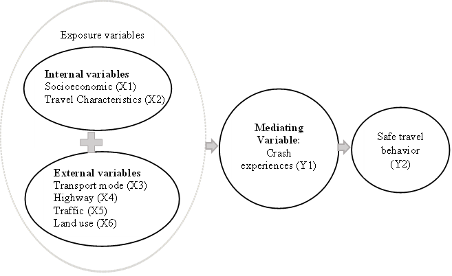
Therefore, this conceptual review aims to synthesize current research on the links between exposure variables, crash risk, and safe travel behavior among suburban commuters, particularly motorcyclists, and to examine how crash experience mediates the relationship between environmental exposure and behavioral adaptation. To address these gaps, this study proposes an integrated conceptual framework (Figure 1) that shows how external and internal factors affect motorcycle crash experience and safe travel behavior in emerging economies. Socioeconomic parameters (X1) consisting of economic and social conditions30, 54), and travel characteristics (X2) including trip distance, frequency, temporal patterns, and route preferences9), are included.
Transportation modes (X3), which encompass private motorcycles (X3B) and online motorcycle taxis (X3A)55); road conditions (X4), which are indicative of the quality of infrastructure and geometric design56); traffic conditions (X5), which are indicative of operational performance, flow, and congestion57); and land use development (X6), which encompasses patterns of human activity and spatial development, such as terrain, density gradients, and mixed-use development, which influence trip generation and modal split58), and have been demonstrated to influence traffic safety outcomes in urban areas59).
In this framework (Figure 1), crash experience (Y1) serves as a mediating variable, not simply an outcome between exposure variables (X1, X2, X3, X4, X5 and X6) and safe travel behavior (Y2). The process by which environmental exposure results in behavioral change provides theoretical support for this position. Crash experience (Y1) including crash frequency, severity, and total crashes represents observable crash patterns that serve as risk information signals, triggering threat assessment and driving behavioral adaptation.
Exposure to road conditions such as inadequate road geometry, high traffic volume, or a lack of road equipment does not automatically translate into behavioral change; rather, the association between exposure and behavior is substantially mediated by accident-related risk information60). Risk perception mediates the relationship between driver demographics and risky driving behavior61). Furthermore, the relationship is moderated by the mode of transportation, whether it be a private motorcycle or an online motorcycle taxi, which either strengthens or weakens the impact of the crash experience on subsequent behavioral adaptation.
Empirical support for this mediation pathway is further provided by evidence that accident information reorganizes risk schemas and motivates behavioral change62), including SEM-based findings on the mediating role of traffic safety awareness in the relationship between road safety attitudes and driving behavior63).
The contribution of the conceptual review is to consider external and internal factors influencing safety aspects and changes in safe travel behavior among residents living in suburban areas of large cities in developing countries, particularly Indonesia. This study adds three elements: (1) a behavioral-contextual paradigm that explains the direct, moderating, and mediating relationships between exposure variables, crash experience, and safe travel behavior (Figure 1); (2) an operationalization of safe travel behavior as a multidimensional construct comprising regulatory compliance, cautious driving, perceived safety and comfort; and (3) a repositioning of crash experience as a mediating variable rather than a terminal outcome, grounded in risk perception theory.
There are five hypotheses to be tested. H1: Exposure variables significantly influence suburban crash patterns. The frequency, number and severity of accidents occurring in suburban areas are largely determined by socioeconomic factors (gender, age, income, education, occupation, driver's license), trip characteristics (cost, length, time, frequency), road conditions (pavement, road equipment and signs, geometry, road structure, queues, accessibility/integration), traffic conditions (volume, side friction, speed), and land use patterns (development opportunities, mixed land use). H2: The association between suburban exposure conditions and collision risk is moderated by the mode of transportation. The principal means of transportation for commuters in low-density suburban areas with little mixed-use development and poor accessibility are increasingly private motorcycles or online motorcycle taxis. The exposure-crash relationship is moderated by this motorcycle dependence: commuters who rely on motorcycles are more vulnerable to the effects of suburban development conditions on accident risk, as their exposure is increased by longer travel distances, more frequent trips, and higher traffic volumes than those who use other modes.
Further hypothesis, H3: Crash experience mediates the relationship between exposure variables and the three dimensions of safe travel behavior. The experience of crashes, encompassing frequency, quantity, and severity, is anticipated to mediate the association between exposure variables and safe travel behavior by influencing commuters' risk perceptions. Behavioral responses in three dimensions will result from this: regulatory compliance (adherence to traffic laws), cautious driving (driving attentively and prudently), and perceived safety and comfort (experiencing tranquility, security, and ease). H4: The current guidelines for safe travel behavior are inadequate for suburban settings in developing countries. The three behavioral dimensions of regulatory compliance, cautious driving, and perceived safety and comfort are fundamentally shaped by structural constraints that are reflected in the exposure variables of this review: inadequate pavement and road equipment, poor road geometry and structure, limited accessibility and integration, queuing conditions, and affordability limitations restricting mode choice. Conventional definitions ignore these constraints. H5: An integrated conceptual model linking exposure variables, crash experience, and behavioral dimensions improves suburban transport planning. A more integrated conceptual model that systematically links the six categories of exposure variables (socio-economic, travel characteristics, transportation modes, road conditions, traffic conditions, and land use patterns) with crash experience, and subsequently with the three dimensions of safe travel behavior: regulatory compliance, cautious driving, and perceived safety and comfort is expected to provide better information for suburban transport planning and to reduce crash risks through targeted, evidence-based policy interventions.
In order to comprehend safe travel behavior, the study used a novel approach to data synthesis that combined qualitative and quantitative methods. The results of this study are expected to address the gaps in earlier studies, notably regarding the relationship between safe travel behavior and crash experiences as a mediating variable. This approach is the foundation for creating a sustainable housing area that emphasizes encouraging commuters to drive safely, especially motorcyclists, who are most frequently affected and are accident victims.
The sections that follow provide a conceptually oriented review of the existing literature on the urban sprawl phenomenon, traffic safety, and travel behavior. The first section of this study explains the theories of internal and external variables, crash experiences and safety behaviors and the relationship between traffic crashes and safe travel behavior remains unclear and even contradictory, particularly in developing countries due to urban sprawl. The second section proceeds to measure the exposure variables that contribute to the high crash risk and unsafe travel discussed in this study and discusses their potential shortcomings in maximizing safe travel on suburban road networks. The article concludes with a discussion and argumentation for a more robust theoretical framework on exposure variables and traffic risks associated with safe travel, as well as improved research designs to clarify indicators reflecting safe travel behavior to minimize the likelihood of crashes for motorcyclists.
2. Methods
This study focuses on safe travel behavior, with a primary review of the literature, particularly for commuters' behavior when using motorcycles. It emphasizes small residential areas, specifically suburban neighborhoods, where people live.
This conceptual review investigates safe and unsafe travel behaviors among motorcycle commuters in suburban, low-density residential areas of developing countries. This study, which focuses on understanding the complicated dynamics of movement, collision dangers, and spatial relationships in a complex urban setting, sets strict inclusion and exclusion criteria utilizing a sophisticated multidimensional methodology.
The study intends to produce new insights into the complex nature of travel behavior by using this cutting-edge analytical technique, going beyond conventional descriptive studies to offer a more thorough and nuanced understanding of mobility dynamics in difficult urban situations. To implement the methodological approach, two sets of phrases were searched. The first was to find literature on accidents involving private vehicles as victims, and the second was to search literature related to safe travel behavior. Terms related to accidents include “accident”, “collision”, “accident victim”, ‘injury’, and ‘safety’ and variations of those terms. While search terms related to safe travel behavior include “travel behavior,” ‘safe travel,’ ‘commuter behavior,’ and” safe travel behavior.” The databases Google Scholar, Scopus, Science Direct, Mendeley, and Web of Science were searched using these terms. The results are 404 papers identified for closer examination. Furthermore, the abstracts of these papers were reviewed to determine whether the unit of analysis was a representative term searching, such as sex, age, education, income, and occupation, as the unit of analysis of socio-economic status. All such papers were included, and no other criteria were excluded. Literature reviews in the original list were also included. After this screening stage, there are 213 papers identified for full review.
The next step was to compile a summary of all the publications included in the entire review, detailing the research location, the unit of analysis, the victim accident rate, the statistical approach, crash types, the treatment of exposure as a concept, and the principal conclusions. Additional papers from forward and backward searches, which focus more specifically on a particular issue, were also included, even though these 213 papers are the primary focus of the analysis. This step is necessary because more literature is needed to examine a particular topic of interest. Travel patterns in developing countries are used in several of these other relevant publications.
Techniques to eliminate potential bias and maintain methodological openness were elaborated upon by the inherent limitations of the literature review process. A critical approach to mitigating individual interpretation bias is to involve a large number of impartial assessors.
The review process upholds high standards of scientific impartiality by using a consensus-based methodology in which disagreements are methodically examined and settled. The quality assessment framework emerges as a very complex component of this scientific approach.
This study employed a data synthesis strategy that integrated qualitative and quantitative approaches64,65) to understand safe travel behavior. By adopting methodological complexity, this study explores the dynamic interactions between socio-economic and travel characteristics, traffic conditions, infrastructure, socio-spatial configurations, and crash risks, challenging existing conceptual frameworks through a rigorous and open analytical approach.
3. Theory: Exposure Variables, Traffic Accidents and Safe Travel Behavior
Traffic crashes and several aspects related to accidents resulting from urban sprawl, with the development of settlements on the periphery, have been studied since 200266). Several impacts of urban sprawl include increases in dependence on cars, car accidents, air pollution, and pedestrian injuries and fatalities. Higher traffic fatalities occur in denser areas67). Other studies, road crash risk analysis related to spatial distribution of residential choice with case studies in the German States of North-Rhine Westphalia and Lower Saxony68); an inefficient traffic network system and ineffective management, resulting in high volume capacity ratio (VCR) more than 1, traffic accidents, and air pollution also occur in Thailand69); there is the connection between city-level traffic congestion and fatalities from traffic accidents in an extensive network of roads due to higher speed variance among vehicles for big European cities57).
Previous studies explain the partial relationship between travel behavior changes and subsequent accident rate changes due to urban sprawl. For example, the development of settlements on the periphery will increase daily mileage by teenage drivers as well as fatality risk among teenagers70,71); sprawl also has a significant direct impact on higher speeds and an indirect impact on longer travel distances that can result in fatal crash rates56).
Research related to accidents in suburban areas mainly examines accident reviews and travel behavior, along with the factors that partly influence them. There is limited empirical evidence explaining the direct effects on driver behavior during travel, especially among motorcyclists, who are affected by these accidents, making up about 63% of all traffic accidents. The number of accidents continues to rise each year due to insufficient handling of road safety programs72).
Several factors, such as social, economic, physical, environmental, and human factors, are associated with safe driving behavior73). Concerning spatial structure patterns and the correlations between urban form and travel behavior, disaggregated data are used for comparison74). The increasing number of households relocated to suburban cities increases travel distances, resulting in increased car ownership.
Existing research is still partial, so policies to minimize the impact of urban sprawl are not optimal, such as, land use policies have a significant effect on traffic safety research conducted by (Asadi, 2022)59), trends in spatial changes and the dynamics of traffic accidents must be applied in Asian countries75), Law No. 41 of 2009 failed to be implemented because the focus on resolving urban sprawl with the implementation of sectoral policies, limited to the agricultural sector alone and not connected to policies on providing housing and limiting motorized vehicles76).
The results of this study will fill the gap left by previous research, specifically regarding the relationship between exposure variables and safe travel behavior, with accident rates acting as a mediating variable, as seen in Table 1. This concept serves as a foundation for developing a sustainable settlement model. The study focuses on creating sustainable settlements that emphasize safe travel behavior for drivers, particularly motorcyclists, who are most often injured in accidents.
Table 1: Summary of impactful studies on exposure variables and traffic safety outcomes
| Study | Country / Context | Method & Data | Key Findings | Contribution to This Conceptual Review |
|---|---|---|---|---|
| Frumkin (2002)66) | USA | Narrative synthesis of public-health evidence on sprawl | Established sprawl as a driver of car dependence, road crashes, air pollution, and pedestrian injuries and fatalities, initiating the sprawl linkage safety research agenda. | Historical starting point since 2002 linking peripheral settlement development with crash outcomes (X6→Y1). |
| Ewing, Schieber and Zegeer (2003)67) | USA (448 counties, 101 metro areas) | Sprawl index through principal component analysis and regression on fatality rates | Denser locations had greater traffic fatalities per exposure, but more compact counties had lower all-mode and pedestrian traffic fatality rates. | The density–fatality link that underlies H1 (land usage → crash severity) has an empirical foundation. |
| Scheiner and Holz-Rau (2011)68) | Germany (North-Rhine Westphalia, Lower Saxony) | Residential-location approach: two case studies of crash risk | Road crash risk is correlated with the geographical distribution of residential choice, meaning that people's exposure to crashes is influenced by where they choose to live. | Supports the perceived safety and comfort dimension and the residential-location → exposure pathway that is essential to H1. |
| Iamtrakul and Klaylee (2021)69) | Thailand (Pathumthani suburb) | Commuter survey; volume capacity ratio (VCR) analysis | In a suburban environment, ineffective network management resulted in VCR ≥ 1, increased crash frequency, and air pollution. | Demonstrates how suburban network inefficiency (X4, X5) affects collision probability in developing nations. |
| Albalate and Fageda (2021)57) | Big European cities | Panel analysis of indicators related to traffic and road safety | Traffic fatalities on large road networks are associated with city-level congestion, which is caused by increased vehicle speed variance. | The traffic-condition variable (X5) and the congestion-fatality mechanism that inform H1 are grounded. |
| Trowbridge and McDonald (2008)70) | USA | Teenage daily mileage compared to sprawl analysis | Teenage drivers' daily car miles increased as a result of peripheral settlement, increasing their fatality risk. | Demonstrates the susceptible group's sprawl (X2→Y1) → VMT → fatality chain. |
| Travisi, Camagni and Nijkamp (2010)71) | Italy | Sprawl and commuter modeling research | The mobility cost of scattered growth was confirmed by urban expansion, which increased commute distance and related hazard exposure. | Supports the use of trip-characteristic exposure (X2) as a crash risk predictor in H1 and H2. |
| Ewing, Hamidi and Grace (2016)56) | USA (metropolitan counties) | Modelling structural equations using the most recent compactness/sprawl index | Higher speeds and longer travel distances are two major direct effects of sprawl that increase the number of fatal crashes. | Provides establishes crash experience (Y1) as a mediator in H3 by providing the direct–indirect (mediation variable) modeling logic. |
| Abusini and Ambarwati (2017)72) | Indonesia (highland road sections) | Motorcycle Accidents: A Generalized Linear Model | Approximately 63% of traffic accidents include motorcyclists, and yearly increases are linked to inadequate road safety initiatives. | Explains why this review focuses on motorcyclists and why H4 should be framed in terms of developing nations. |
| Patwardhan et al. (2020)73) | Multi-context (travel research) | An analysis of personal, social, economic, physical, and environmental aspects | Rather than a single predictor, a wide range of social, economic, physical, environmental, and human elements are linked to safe driving behavior. | Supports the operationalization of safe travel practices in multiple dimensions (Y2). |
| Figueroa, Nielsen and Siren (2014)74) | Comparative (age cohorts) | Comparison of disaggregated data on travel behavior and urban form | Context-dependence is highlighted by the differences in correlations between urban form and travel behavior among demographic groups | Encourages a context-sensitive, broken-down examination of the relationships between exposure and behavior (X1-X6 → Y2). |
| Asadi et al. (2022)59) | Netherlands (Dutch urban areas) | Comprehensive built-environment–safety analysis | Land-use diversity is linked to different crash outcomes, and land-use layout has a major impact on traffic safety. | H1 and the land-use policy argument are informed by central evidence that land use (X6) significantly impacts safety outcomes. |
| Umair, Rana and Lodhi (2022)75) | Pakistan (Rawalpindi) | An analysis of the built environment and urban planning in relation to crashes | Spatial change trends and accident dynamics must be explicitly modelled in Asian developing-country cities. | Strengthens the framework's applicability to Asian developing nations and the transferability argument (H4). |
| Nurrokhman (2019)76) | Indonesia | Policy analysis of sprawl and land-protection law | Law No. 41/2009 failed because it only tackled sprawl through sectoral (agricultural) policy, which was unrelated to housing and vehicle-restriction policies. | Demonstrates the integrated-policy gap that H5 seeks to address through a combined exposure–behavior framework. |
| Current conceptual review | Indonesia | Conceptual review / developing-country suburban context, particularly Indonesia | An integrated conceptual model linking exposure variables, crash experience, and behavioral dimensions improves suburban transport planning. | Proposes an integrated contextual-behavioral framework in which crash experience mediates the relationship between exposure variables and safe travel behavior, specifically for motorcyclists riding on-line or private motorcycles in suburban areas in developing countries. |
4. Measurement of Exposure Variables on Traffic Risk and Safe Travel Behavior
Due to the complexity of distinguishing between factors influencing traffic risk and safe travel behavior, it is necessary to refer to numerous literature sources on both topics. Several exposure factors influence both terms, while others affect only one of them.
Exposure variables independently influence crash incidence and safe travel behavior. This review should begin by explaining the differences between each exposure variable and how they impact the relationship between traffic accident features and safe travel behavior.
Some research related to urban development includes an extensive road network that impacts safety77); infrastructure development and road networks extending to the suburbs that promote new growth along access roads78,79), which leads to the expansion of residential areas, population growth, and an increase in the number of housing units in the suburbs.
4.1. Socio-economic background
Socio-economic background is a measure that combines a person's work experience or their family's access to economic resources and social standing. It relates to a person's income, employment, and social background, which are key factors determining future success and life opportunities. Better health outcomes are often positively correlated with socio-economic status (SES), which is a composite assessment of an individual's economic and social standing. Education, earnings, and employment are three typical indicators of socio-economic position80).
The socio-economic and demographic characteristics of families living in suburban areas in Indonesia have unique characteristics that influence travel behavior, as observed in Makassar, Yogyakarta, and Surabaya. The expansion of growth centers from the city center to suburban areas impacts accessibility, the availability of new public services (health, education, worship, and large-scale trade), as well as regional development and physical features32). Land use changes and suburbanization shape socio-economic dynamics, leading to social transformation in local communities along the Tun Abdul Razak Road Corridor in Makassar; urban expansion in the Kotagede, Mantrijeron, and Wirobrajan districts of Yogyakarta results from high population pressure caused by population growth and economic activity in these suburban areas81).
Many models focus solely on land price variables when choosing housing locations and urban distribution types, but few consider other factors like socio-economic aspects (education level, economic conditions, and family welfare)82); there are seven factors impact on settlement preferences, i.e. community social activities, educational background, length of stay, vulnerability to liquefaction and fracture disasters, accessibility, and distance from the city center are seven characteristics that impact relocation preferences83).
Urban expansion affects the construction and operational costs of public facilities funded by the government, due to inefficiencies in building roads, schools, waste management, and related issues like accidents and environmental concerns84). This expansion also influences the rise in homeownership and socio-economic homogeneity in Leipzig, Germany. A link between urban sprawl and social conditions, such as education levels, economic status, family welfare, and land prices, is further explained by Pahlevi (2023)85). The gender and age of victims, as well as the area’s designation as rural, are the most significant factors. The driver’s gender, land use, pavement conditions, and attitude are also identified as important factor86).
An increasing quantity of empirical evidence supports the application of this paradigm to the Indonesian and developing world settings, despite the fact that the study's theoretical underpinnings are primarily taken from European and North American literature. Due to notable disparities between Indonesia and high-income nations, such as vehicle composition, road user behavior, and infrastructure quality, motorbikes were noted to be involved in 78% of all accidents in 2023, resulting in a total of 27,000 fatalities87).
A study on road traffic facilities, crashes, and poverty in Indonesia revealed that socioeconomic factors, in particular, poverty, vehicle type (private or public), and daily trip frequency have a significant impact on crash involvement88). It also explained that private vehicle users have a 6.5% lower probability of never having experienced a crash than public transportation users, due to the inability to control vehicle movement and driver compliance in public transportation. Therefore, this study emphasizes the internal socioeconomic factors of commuter suburbs in Indonesian cities.
4.2. Travel Characteristics
Travel characteristics are a set of attributes that describe the nature, patterns, and behavior of movement from one location to another by individuals or groups. These characteristics include spatial, temporal, transport mode, and behavioral dimensions that form mobility patterns in transportation systems. These attributes describe a journey, including origin-destination, time, mode, purpose of travel, and characteristics of the traveler that influence mobility patterns86).
It is revealed that there is a relationship between urban sprawl and socio-economic characteristics and travel patterns in Iranian cities30). In metropolitan regions, increased automobile ownership in cities has led to traffic congestion, pollution, accidents, and a decrease in nonmotorized transportation modes in most Indian cities. The development of sustainability indices for urban transport systems in developing-country cities faces significant challenges, as demonstrated in the case of Jaipur, India, where rapid motorization and increasing automobile ownership have intensified congestion, pollution, and accident risks89). Excessive auto use raises the risk of traffic fatalities, and urban development increases auto-dependency. By preventing growth in the suburbs and encouraging compact development, traffic safety can be enhanced. Data collected nationally from 147 urbanized areas in the United States are used to analyze these connections90).
An analysis of road traffic accident risk factors in rural and urban areas of Indonesia using national survey data conducted by Zainafree et al. (2022)91), found that trip distance, road type, and vehicle type were significant predictors, confirming that these variables are similar on suburban Indonesian roads as in Western contexts, although mediated by different levels of infrastructure quality.
A recent study on motorbike taxi and private motorbike drivers in Greater Jakarta found that the main behavioral factor contributing to accidents was driving errors brought on by moving violations, and that insufficient infrastructure (poor road markings, no designated motorcycle lanes) increased the risk92). This pattern is not typically observed in European/American cities, where motorcycle use is much lower. Therefore, this study focuses on the internal travel characteristics of commuters to consider their safety during travel.
4.3. Transport mode
Transport modes are the means used to move people, products, or cargo from one location to another. Transportation modes encompass automobiles, operating systems, supporting infrastructure, and the technology that facilitates mobility within the transportation system. Transportation modes are also defined as a technological system consisting of infrastructure, vehicles, and operational procedures that enable the movement of goods and passengers with specific technical and economic characteristics93,94). A land transportation infrastructure system consists of interconnected and integrated road segments to serve the movement of people and goods95).
People use public transportation, particularly trains, to connect with walking, and pedestrian space is crucial. The impact of space permeability and accessibility on railway station mobility is required, as the comfort and smoothness of a space with its amenities are referred to as accessibility and permeability of space96,97). China's experience in Next Generation Vehicles (NGV) deployment shows that strategic government intervention can successfully accelerate technological transition. China's comprehensive regulatory and subsidy framework has successfully created a paradigm shift in the global automotive industry, which could serve as a guide for other countries seeking to promote sustainable transportation solutions98).
Households and individual decisions, such as neighborhood selection and transportation mode, are influenced by lifestyle and mobility patterns55). The tour mode choice problem and quantifying forward-looking aspects in the mode-choosing process can use the logit model structure, which is frequently used in path choice modelling. The model can assess people's forward-looking behavior and learn how earlier mode choice decisions in the day are influenced by future trip considerations, such as an evening shopping trip or a school pick-up trip99).
Property values may benefit from the expansion of the public transit network. According to this study, the following characteristics significantly affect the price of residential real estate: unit area, shared building, shared land, land area, building area, density, and the distance to public parks, mass rapid transit, central business district, hospitals, and favored high schools100). Thus, this study focuses on considering the transport mode that is commonly involved in traffic accidents.
Road users in low- and middle-income countries (LMICs) are affected by a lack of legislation and enforcement, so 40% of crash deaths in South Asia involve two- and three-wheeled motorized vehicles, as informed by the WHO South-East Asia Regional Status Report on Road Safety (2024)101). Significant deaths and disabilities could be avoided if ASEAN countries adopted appropriate vehicle safety regulations. Furthermore, this study identifies crash exposure and behavioral pathways specific to developing countries where vehicle safety features still fall short of Western standards102).
4.4. Highway condition
Road condition refers to the structural, functional, and physical status of road infrastructure at a specific moment in time, indicating the degree to which a road can offer road users efficient, comfortable, and safe transportation services. Geometric features, pavement, drainage, road equipment, and other elements that impact road operational performance are included in road condition103).
The primary causes of vehicle accidents are road conditions and other factors, such as driver behavior and vehicle speed. The results indicate that pedestrian safety is substantially influenced by perceptions of elements such as buffer zones, inadequate infrastructure maintenance, risky driving, and walking ease. At the same time, there are perception aspects specific to a city, like pathway continuity, zebra crossings, and satisfaction with nighttime conditions104). This study also explored how lane-width, shoulder-width, and their combinations affect safety on rural two-lane two-way roads in Illinois and Minnesota. According to lane width indicators, the total number of crashes (of all types and severities) increases when lane width decreases, and shoulder width is ignored. Conversely, the number of crashes decreases as shoulder width increases, which was the main factor affecting crash rates105).
Determination of the quantity and kind of safety interventions should be applied throughout an extensive road network made up of many types of road features. This study suggests an integrated multi-layer framework that incorporates the issues into a single optimization process. The estimation of safety performance for each road category is used to assess the potential for safety improvement quantitatively; a bi-level thresholding process integrated into the optimization process is used to highlight intervention sites; and the available crash reduction factors are used to assess the expected outcome of safety measures quantitatively66).
Another study proposes a Bayesian Conditional Autoregressive Poisson Log-normal model to examine the safety effects of suburban arterial characteristics, including signal density and access density, alongside zone road network features such as road network patterns and density in the Shanghai suburban area. The findings indicate that road networks with grid designs and collector roads running parallel to arterial routes have a lower accident rate. However, on suburban arterial roads, accidents are more likely when there is lower road network density, higher signal density, and greater access density106). Mastrip Highway in Surabaya city, Indonesia, is a primary collector road consisting of two types of roads: 4/2 UD (four-lane two-way undivided) and 2/2 UD (two-lane two-way undivided). There is no median along the highway, only straight markings. Mastrip Highway is 7.77 km long with an average width of 3.25 to 3.50 meters. Its considerable length and width encourage drivers to exceed the speed limit. The land use around Mastrip Highway, designated for industrial, commercial, and residential purposes, leads to road shoulders being used as parking spaces, requiring drivers to exercise extra caution. Causes of accidents include obstructed visibility due to parking, inadequate signage, and signs being obscured by trees or buildings107).
Other research emphasizes road performance related to the use of the road corridor for trade and services, which has the most significant internal impact. Widening roads by 0.5 meters from their current width and establishing regulations to manage land use changes will improve road performance. Public safety and mobility are crucial, but so are clean air and streets that are accessible for pedestrians. Additionally, traffic engineers have historically evaluated performance based on motor vehicle volume rather than human traffic. Consequently, there is a vicious cycle of building more roads to accommodate motor vehicle traffic instead of investing more in public transportation and bicycles, which efficiently utilize road space108).
4.5. Traffic condition
Traffic conditions refer to the operational state of vehicle movement on a road section or road network at a given time, which reflects the performance level of the transportation system in serving traffic movement. These conditions encompass aspects such as volume, speed, density, service level, and traffic flow characteristics that influence the efficiency, safety, and comfort of travel109).
The following factors of traffic condition are speed, congestion, and road horizontal curvature. Enhancing data quality, investigating factors in rural and emerging regions, and using sophisticated statistical models are some of the future research goals for examining the impact of variables. Furthermore, it is necessary to investigate whether curvature increases road safety, how speed and traffic affect accidents, and the application of more advanced statistical models to better understand the impact of variables110). To improve road safety, encourage sustainable urban transportation options, and create more livable urban settings in different cities around the Republic of Croatia, this study investigates the scenario surrounding the adoption of 30 km/h traffic zones in urban areas. The study examines the effects of lowered speed restrictions on accident rates, pedestrian safety, and general traffic flow by reviewing relevant literature and EU city best practices111).
Reducing speeding-related collisions can be achieved by controlling speeds through the use of geometric design components or traffic calming techniques. TRB committees have the chance to support this effort by measuring reliability, for instance, which provides further insight into a highway's operational performance by acknowledging that metrics like speed, capacity, and delay depend on a variety of variables, including geometry sensitivity. The effort also anticipates the demand for walking and bicycling spaces, which will continue to grow in terms of transportation mode share, particularly as understanding of how geometric design features affect experience quality and safety performance advances112).
As a result, the traffic flow structure is evolving, making the traffic stream more diverse and potentially more hazardous. This condition indicates that motorways need to handle increased traffic volumes. As traffic becomes more varied, the quality of the travel experience diminishes. According to the models created, the increasing volume of traffic and changing traffic patterns are likely to affect traffic safety for the Slovenian motorway system negatively. The study found that, compared to the European average, the number of HGVs involved in traffic incidents on Slovenian roads is notably higher113). Using real-time data from current traffic intersection cameras, this study aims to develop a dynamic, fully autonomous deep learning model that processes the data and generates an intensity score based on traffic density in each neighboring lane114).
Differences in the traffic mix (car-dominant versus motorcycle-dominant), law enforcement capacity, road infrastructure standards, and cultural driving norms may potentially vary the strength and direction of the links observed in Western environments115-117). Although particular exposure conditions, crash profiles, and behavioral responses vary contextually, the theoretical process underlying our framework that environmental exposures generate crash patterns that might activate adaptations to safer travel behavior is universal118). This study contributes to addressing this gap by empirically testing the framework in the context of suburban streets in Indonesia.
4.6. Land use condition
The state of human activity and spatial utilization in a given geographic area at a given time is known as land use conditions. This includes the type, intensity, patterns of spatial distribution, and dynamics of changes in land use for different purposes, such as open space, commercial, industrial, residential, and transportation. Land use conditions are a comprehensive measure of how land is utilized in an area and how this affects and is affected by transportation systems and mobility patterns. Understanding land use conditions is crucial for planning and designing sustainable cities and transportation systems that efficiently fulfil the needs of residents, businesses, and industry119).
The study reviews the connection between road safety and the built environment, focusing on examining small geographic units like trip analysis zones or census tracts. This study also clarifies the correlations between built environment features and crash rates resulting from either higher exposure, which is frequently not sufficiently controlled for, or exposure levels or greater crash risk rates per exposure unit. Thus, it is categorized into different built environment characteristics as either ambiguous, more associated with risk, or more related to exposure58). In Indonesia, Surabaya's rapid growth can be attributed to its classification as a national activity center. As a result, human relationships and motions increase in tandem with development. The degree of sustainability of Surabaya's mobilization is assessed using both regional compactness and population mobilization. Mobility level analysis and compaction level analysis based on movement behavior are among the techniques employed in this study. With a comparatively near arrangement of service centers throughout the district, Genteng subdistrict in the Surabaya center has the highest level of regional compactness. It is anticipated that the findings of this study will be used to develop urban spatial structures that promote sustainable people-mobilization practices120).
The long-term, indirect consequences of land usage on land-use planning and policies are the main subject of this study. According to the findings, land-use development that causes traffic congestion occurred after increases in road capacity. Planning policies and methods varied, which had an impact on how traffic-inducing the land-use development was121). For a long trip, a public space is required for a rest area, which is selected depending on the selection preferences of drivers. The natural environment around rest areas has also been proven to influence selection behavior significantly122). Suropati Park, Jakarta, as a public area, can produce activities that promote the well-being of its patrons, as evidenced by the prevalence of different kinds of energetic and passive activities that can be done alone or in groups123). Capturing the current indoor thermal environment and thermal characteristics of building envelopes in low-cost dwellings within a Kampung is crucial. This condition will enable the presentation of affordable countermeasures against future climate change, thereby mitigating various health risks124,125).
The city transformation exhibits resilience through adaptation and planning, as evidenced by the city elements related to defense, economy, and food supply, which support the city's self-sustainment. Due to its continuous development, Banten, which supports Jakarta, has reached its pinnacle and is now a safe city for international trade. It has also managed to withstand numerous challenges and threats from the region's ongoing conflict126,127).
The results suggest that the primary drivers of the circular economy's adoption in India's industrial sectors are technical (ETE) and financial (EFI) enablers. The industries are better able to understand the factors that facilitate the circular economy and create workable implementation strategies128). The rapid urbanization of the world raises concerns regarding the provision of urban green infrastructure. To determine how urban green spaces (UGS) and urban greenways (UGWs) could contribute to the revitalization of urban surroundings, this study examines Pune, India. Urban Greenways are networks of linear open spaces that improve socio-economic and ecological benefits129).
The development of a city has an impact on the mobility and interaction of its population. The sustainability of Surabaya's population movement is assessed using both population mobilization and regional compactness. Given the very close concentration of service hubs in the area, the Surabaya Center exhibits the highest level of regional coherence. It is expected that the findings of this study will be applied to the development of urban spatial structures that encourage sustainable population mobility130). Development in the suburbs has an impact on a change in travel behavior, which is caused by an increase in traffic generation, accompanied by a tendency to use private vehicles, and higher mobility in the suburban areas131). Focusing on different land-use patterns due to suburban development in developed countries, such as the Netherlands and Flanders, Belgium, shows that regional land use significantly impacts travel behavior. Travel habits in both regions seem to be influenced by their distinct land-use patterns. Since a significant portion of the population regularly walks, cycles, or takes public transit, the Netherlands' active spatial planning approach, which concentrates activities in urban areas, appears to have achieved sustainable travel behavior132).
According to the megalopolis agglomeration model, a novel approach to urban development, established regional networks are often undermined by urban structure, and even economic networks are drawn back into the intra-urban scale. This model is a hypothesis that requires empirical support from additional studies. Furthermore, the results support the claim that the integrated and compact intra-city model is relevant for upcoming urban research and policy development133-135). Malang metropolis's urban expansion is still dispersed unevenly around the metropolis. This suggests that the infrastructure facilitating urban growth is not distributed fairly. Therefore, increased funding for the city's infrastructure is essential. Equitable infrastructure development can encourage growth in other areas, satisfying the need for available land for residences and communities136).
4.7. Traffic accident
Accident rate for the road segment expressed as accidents per 100 million vehicle-miles travelled137). The possibility of the occurrence of a crash event means the number of crashes divided by the size of the population (i.e., road fatalities per 100,000 population) or by the amount of travel that people engage in (i.e., road fatalities per billion vehicle kilometers travelled). The units of measurement, however, have no bearing on coefficient estimations because all variables are recorded in the empirical analysis138).
Road traffic accidents (RTIs) account for 90% of global deaths in both low- and middle-income countries139); the burden of RTIs is not only a public health threat in developing countries, but also in developed countries140). Traffic accidents are a threat to society and are a significant source of disability in both developing and developed countries141).
Some studies have focused on crash causal factors. For example, an examination of the relationship between crash density, suburbanization, and environmental factors involving vehicles in the Chengdu city area, China was conducted45). Cities with less severe congestion need to focus on other aspects of safety, as reducing congestion increases the risk of fatal crashes. A rise in fatal and serious injury crashes is directly correlated with an increase in traffic congestion. Specifically, a 0.1% increase in crashes is expected for every 1% increase in traffic delay per kilometer.
Traffic congestion is linked to more fatal and serious injury crashes due to higher speed variations among vehicles within and between lanes, erratic and more aggressive driving behavior in congested situations, and relatively high speeds in crowded conditions, especially on main roads110).
Regarding accidents caused by road network expansion, for example, research conducted in western Iran shows that most deaths in suburban areas are caused by motor vehicles. In contrast, in urban areas they involve pedestrians. Therefore, improvements to highways are needed, such as road design with stricter enforcement of laws and camera monitoring to reduce the number of deaths from traffic accidents142). The influence of intersection density and road type on traffic accident fatality rates on roads is explained by (D. Mohan, 2017)143), who states that cities with a higher proportion of wider roads and larger city neighborhoods tend to have higher traffic accident fatality rates.
Risks faced by four thematic villages in Malang City are categorized into four hazard families: geophysical, hydrological, biological, and anthropogenic hazards144). Anthropogenic hazards are hazards caused or triggered by human activities, including environmental degradation and technological hazards that can threaten lives, livelihoods, health, the economy, the environment, and traffic accidents145). The risk results for urban villages with a moderate risk rating should be in line with the policy priorities chosen by the central and local governments.
A model for motorcycle accidents based on rider characteristics, such as socio-economic factors and movement patterns146). Accidents happen on road sections in Surabaya City that are prone to crashes and serve as routes to the city center from the western part of Surabaya147), road networks leading to the city center or bordering other areas148). Although case studies provide fascinating insights into accident models, more empirical research is needed to understand the behavior of residents living in suburban areas. This situation can help explain how their travel behaviors influence accident rates among private vehicle riders, especially motorcyclists, and clarify the specific relationship between their travel patterns and certain types of accidents caused by settlement expansion into suburban zones.
Over half of all traffic crash fatalities globally involve pedestrians, cyclists, and motorcyclists, and these incidents primarily occur in low- and middle-income countries, according to the WHO (2023)87). The research confirms that the mechanisms underlying the links between land use patterns, traffic conditions, and crash experiences differ in developing and high-income nations, as shown in Table 2.
4.8. Safe Travel Behavior
Safe travel behavior involves actions, attitudes, and practices by road users to reduce the risk of accidents, injuries, or other losses to themselves, other road users, and the environment. This behavior includes obeying traffic laws, using safety equipment, making wise decisions, and adjusting to road and traffic conditions149). It reflects a high level of safety awareness, understanding of risks, and the ability to make proper decisions in dynamic and unpredictable traffic situations.
According to the results, pedestrians can sustain injuries in minor or severe accidents, which may lead to temporary or permanent disabilities. Therefore, drivers need to be aware of electric vehicles when walking on the road150,151).
Individual travel behavior is influenced by a variety of factors, including employment considerations, transit availability, and the demographic and social makeup of the living environment. The greater usage of public and active transportation is linked to higher development density and infrastructure quality, irrespective of socio-demographic composition152). Safe driving behavior is influenced by various social, economic, physical, environmental, and human factors. However, in developing countries, these factors are often linked to inadequate infrastructure and insufficient resource allocation, particularly in areas such as road conditions and driving practices153). Attitudes about safe travel and the mismatch between attitudes and the features of the residential built environment are crucial factors in determining how well land use regulations affect travel behavior. Since there are currently no longitudinal techniques, studies on the nature and directions of causality of the relationships between these factors have been hampered. Using this method, this research investigates how individuals from various demographic groups modify their living spaces and perspectives over time154).
Investigation of factors related to residents' travel patterns and activity spaces, such as travel characteristics, household characteristics, and attitude factors, was conducted155); analysis of the regularity of residents' daily travel behavior and the factors influencing it, such as activity patterns, duration, and competition, should be carried out. Considering these factors, further research is needed to provide insights into safety-focused travel patterns that affect travel demand and trip length at both individual and household levels, while accounting for socio-demographic and residential characteristics, especially in suburban areas.
The section on traffic risk and safe travel behavior provides a detailed study of the numerous issues impacting transportation safety in suburban situations. By investigating many dimensions of mobility, the research indicates that a nuanced interplay of socio-economic background, trip characteristics, transport modes, roadway conditions, traffic characteristics, and land use patterns shapes traffic risk. These variables do not work in isolation but interact in complicated, context-specific ways that profoundly modify the knowledge of transportation safety.
The concept of safe travel behavior is dynamic and multidimensional, comprising interactions across systems that extend beyond the activities of individuals. There are a number of factors that have a substantial impact on safe travel habits, particularly in developing countries. These factors include inadequate infrastructure, resource limits, and complex socioeconomic dynamics.
Table 2: Empirical evidence on the mediating role of crash experience in shaping safe travel behavior
| Ref. | Exposure Variable | Mediating Mechanism | Key Finding | Relevance to the Mediation Pathway (H3) |
|---|---|---|---|---|
| 60 | Road conditions (geometry, traffic volume, road equipment) | Accident-related risk information | Exposure to poor road conditions does not automatically change behavior; the association between exposure and behavior is substantially mediated by accident-related risk information. | Directly establishes that crash-related information mediates the exposure–behavior link, anchoring the core mediation logic of H3. |
| 61 | Driver demographics | Risk perception | Risk perception mediates the relationship between driver demographics and risky driving behavior. | Demonstrates a perceptual mediating channel through which socio-economic/demographic exposure (X1) translates into behavior. |
| 62 | Accident information / technology exposure | Reorganization of risk schemas | Accident information reorganizes risk schemas and motivates subsequent behavioral change. | Supports the cognitive re-appraisal mechanism by which crash experience (Y1) signals risk and drives behavioral adaptation. |
| 63 | Road safety attitudes | Traffic safety awareness | SEM-based evidence shows traffic safety awareness mediates the relationship between road safety attitudes and driving behavior. | Provides quantitative (SEM) validation of an awareness-based mediation pathway consistent with H3. |
| 87 | Vehicle composition / exposure (LMIC context) | Crash exposure signal | Motorcyclists accounted for 78% of accidents and 27,000 fatalities in Indonesia (2023), reflecting distinct exposure–crash patterns in developing countries. | Grounds the mediation pathway in the motorcycle-dominant suburban context central to this review. |
| 88 | Socio-economic factors (poverty, vehicle type, trip frequency) | Crash involvement / risk exposure | Poverty, vehicle type, and daily trip frequency significantly affect crash involvement; private-vehicle users show a 6.5% lower probability of never having crashed than public-transport users. | Links socio-economic exposure (X1) to crash experience (Y1) as the mediating stage before behavioral response. |
| 91 | Trip distance, road type, vehicle type | Crash risk exposure | Trip distance, road type, and vehicle type were significant predictors of crash risk in rural and urban Indonesia, mediated by differing infrastructure quality. | Confirms travel characteristics (X2) feed into crash experience, supporting the exposure→crash→behavior chain in a developing-country setting. |
| 92 | Infrastructure deficiencies + riding behavior | Driving errors / moving violations | In Greater Jakarta, driving errors from moving violations were the main behavioral contributor to crashes, with poor markings and absent motorcycle lanes increasing risk. | Illustrates how road-condition exposure (X4) generates crash experience that reshapes rider behavior (Y2). |
| 104 | Built environment / infrastructure maintenance | Perceived risk of unsafe elements | Perceptions of buffer zones, walking ease, risky driving, and poor maintenance significantly influence pedestrian safety. | Shows perception of risk mediates between physical exposure and safety behavior, reinforcing the perceptual mediation channel. |
| 110 | Traffic congestion / speed variance | Crash risk perception under congestion | Every 1% increase in traffic delay per km is associated with ~0.1% more crashes, driven by higher speed variance and aggressive behavior. | Demonstrates traffic-condition exposure (X5) producing crash patterns that inform subsequent behavioral adaptation. |
| 155 | Built environment + travel attitudes | Residential dissonance / attitude adjustment | A latent-class transition model shows individuals adjust their residential environments and travel attitudes over time, mediating land use–behavior relationships. | Supports the dynamic, attitude-mediated pathway linking exposure to evolving safe travel behavior. |
5. Discussion
There is significant variation in research findings regarding the empirical relationship between internal and external factors influencing crash incidence and safe travel behavior. Measures of internal factors, including socio-economic and travel characteristics, as well as external factors such as transport mode, traffic, highway, and land use conditions, have been shown to affect either the reduction or increase of accidents and safe travel.
This comprehensive analysis reveals significant disparities in current research methodologies, which highlight the challenges in developing useful transportation safety models. Variations in model parameters, geographic contexts, accident characteristics, and commuter views surely have an impact on the complex research settings. These discrepancies show the great complexity of human-infrastructure interactions rather than methodological flaws.
Several specific examples illustrate these conflicting findings regarding socioeconomic status and accident risk. Due to socioeconomic differences, road traffic fatalities are increasing across Ecuador's provinces, as confirmed by Holguín-Carvajal et al. (2024)156). Because of their poor infrastructure and greater reliance on unsafe forms of transportation, low-income areas experience a notably higher rate of traffic accidents157). However, there is a nonlinear, inverted U-shaped association between wealth and traffic deaths in 22 OECD nations158). This relationship is related to Indonesia's current stage of development, as economic expansion initially increased road fatalities due to the rapid increase in motor vehicle use before declining with safety investments.
There is a similar debate on how mixed land use affects accident risk. There are also differing opinions regarding how mixed-use land use affects crash risk. In contrast to enhanced land use diversity, which actually reduces crash frequency59), dense, mixed-use areas increase pedestrian crash frequency by increasing exposure to vehicle impacts159-161). This contradiction suggests a context-dependent nonlinear relationship where high density increases exposure-related problems; on the other hand, the modest mixed use can increase safety by lowering car kilometers driven162).
Traditional engineering methods for enhancing road infrastructure make the assumption that safer roads result in fewer collisions. Road investments in European countries have not consistently reduced injury-related crashes. Behavioral risk compensation significantly outweighs infrastructure benefits163).
Road safety facilities do not consistently reduce crash severity in the Indonesian context, which confirms that there is a decline in outcomes if infrastructure improvements are carried out without appropriate behavioral interventions. These conflicting findings across socioeconomic, land use, and infrastructure domains underscore the need for an integrated analytical framework, such as the one proposed in this study that simultaneously accounts for the complex, nonlinear, and context-dependent interactions between internal factors (socio-economic and travel characteristics) and external factors (road conditions, traffic environment, and land use configurations) in shaping both accident patterns and safe travel behavior.
The main findings and the expected causal basis of these effects are clarified in Table 3. Table 3 shows the current internal and external factors that influence several indicators of accident and travel behavior.
Based on previous research on the relationship between spatial statistical methods and identifying spatial variations in accidents over a specific time interval, as well as comparing accident-prone locations based on accident type and severity index using TAZ (traffic analysis zone)164); the effects of the built environment on pedestrian accident occurrences; and examining spatially heterogeneous relationships (mixed land use) while considering various spatial scales165).
Research on suburbanization impacts travel behavior, including increased vehicle ownership, which results in longer travel distances and times. For example, Hartell A. M. (2017)166) states that denser road networks typical of compact cities are linked to less private car use. (Ettema, 2017)167) used a multivariate model to show that travel attitudes and characteristics affect mode choice and location decisions. (Mouratidis, 2019)31) demonstrated that urban sprawl impacts travel behavior and satisfaction, with a compact city form leading to shorter travel times and higher satisfaction.
So far, minimizing the impact of settlement development in the suburbs has not been effective solely through the integration of land use balance and transportation systems, as other factors have been analyzed partially. Therefore, this proposed research considers the safety aspects of commuter travel for those living in suburban areas, particularly those using motorcycles. The impact on decreasing or increasing accidents and changes in travel behavior focuses on analyzing the factors influencing them from various variables and the interrelationships between variables. The development of a safe travel behavior model in suburban areas will influence risk in the suburban highway network, particularly in developing countries. Therefore, the focus of this research is to determine how the severity of accidents on suburban highways can be reduced and promote safer commuter travel behavior.
Safe travel behavior is a multifaceted construct with three interconnected dimensions that together include safety-oriented behaviors users of suburban road infrastructure take throughout their travels, as seen in Table 3.
The first dimension, regulatory compliance, refers to adherence to traffic laws, posted speed limits, road signs, and other legally mandated driving norms. De Winter and Dodou (2010)168) demonstrated through a meta-analysis that traffic violations are significant predictors of self-reported crashes. Recent studies support this dimension, such as in a developing country environment, a consistent gap between drivers' regulation awareness and their actual compliance behavior169), and deliberate non-compliance was a significant factor in traffic accidents in a variety of national contexts170). Additionally, the best road safety measures were laws and enforcement actions aimed at regulatory compliance, which reduced traffic injuries by an average of 26%, as verified by Akbari et al. (2024)118).
The second dimension, cautious driving, includes proactive safety practices that go beyond following the law, like keeping a safe distance, modifying speed in response to traffic and weather conditions, and anticipating other drivers' potential problems. In the Multidimensional Driving Style Inventory (MDSI), the cautious and patient driving styles are distinct adaptive dimensions identified by (Taubman-Ben-Ari & Skvirsky, 2016; Huo et al., 2022; Rhiu & Kim, 2025)171-173).The cognitive ability to predict the intentions of other drivers, plus the mediation factor of cautious driving, significantly reduces the likelihood of crashes, according to Nori et al. (2024)174), while cautious driving is a proactive behavioral component that is different from merely following the rules175).
To reduce the risk of accidents, commuters strategically choose safer modes, routes, and travel times, which is covered by the third dimension: perceived safety and comfort. Nordfjaern et al. (2014)176) found that commuters who value comfort and safety are more likely to choose public and active transportation. Better danger assessment is associated with social cognition skills, and this translates into decisions on the best course of action and mode of transportation in complex traffic circumstances177).
This construct's multidimensionality is consistent with the wider understanding in traffic psychology that any one component cannot adequately describe safe conduct. Positive driver behaviors, including compliance, safety-oriented actions, and cooperative behavior, are multidimensional traits178). The three dimensions, when taken together, offer an operationalization of safe travel behavior that is both empirically testable and logically justified, setting it apart from more limited concepts like defensive driving, following traffic laws, or simply avoiding risks.
A novel approach to improving transportation safety in suburban areas is suggested by the study. Its main purpose is to identify high-risk locations by establishing a complete land-use and mapping model. By studying external and internal factors driving travel behavior, the study gives a comprehensive tool for understanding accident risks.
Compared to conventional methods of accident investigation, the blackspot mapping model is more sophisticated. This approach creates a sophisticated framework by fusing behavioral traits, infrastructure evaluation, and spatial analysis. This study explains the complex relationship between infrastructure, land use, and human travel behavior, in contrast to conventional techniques. The model provides a multi-layered representation of accident vulnerability.
The blackspot mapping approach gives critical insights for municipal planners and politicians. It discovers high-risk zones by examining road layout, traffic patterns, socioeconomic and travel factors, and land-use mix. This model permits concentrated action that addresses the fundamental causes of transportation safety challenges. It gives a dynamic method for studying accident generation in suburban contexts.
Initiatives for urban development and transportation safety are being transformed by this new mapping technology. It offers a comprehensive, empirically supported strategy for reducing the frequency and severity of motorcycle accidents. Because of its flexibility, the model is a priceless tool for transportation safety professionals, offering a context-specific way to understand mobility problems in suburban areas.
The research contributes to a deeper comprehension of the dynamics of urban mobility. This study creates a strong analytical framework to solve transportation safety issues in emerging nations by challenging conventional wisdom. Scientific research on intricate transportation safety concerns is made possible by the accident black spot mapping technology.
Table 3: The current status of internal and external variables, accident, and safe travel behavior
| Variable | Indicator | Accident | Safe Travel behavior | Dimension of behavior | Citations |
|---|---|---|---|---|---|
| Socio-economic | sex | more at risk of fatal injury due to physical limitations or lack of vehicle protection | Caution, be more careful and obey traffic rules | Regulatory Compliance | 90,132) |
| age | Older, more careful in driving | having a direct impact on the level of safety on the road | Regulatory Compliance | 30,179,180) | |
| income | Higher incomes enable better access to safer vehicles | Higher income influences travel safety behavior | Perceived safety and comfort | 54,82,84) | |
| Education background | Higher education, better understanding of risks on the road | better ability to avoid risky behavior | Precautionary Driving | 84,85) | |
| occupation | High-risk jobs, associated with higher accident rates. | Work influences on safety behavior while traveling | Precautionary Driving | 152,181,182) | |
| Vehicle license | Driver's licenses, decreasing traffic accident rates, | Driver's licenses help increase the basic knowledge and skills needed to drive safely. | Regulatory Compliance | 26,30,131,183-185) | |
| Travel characteristics | cost | Higher transportation costs encourage people to use private vehicles and increase the risk of accidents | Higher costs, increasing the drivers to drive more carefully | Precautionary Driving | 90,132,146) |
| length | Long-distance travel, more risk factors and a greater chance of being involved in an accident. | Long-distance travel, less safety behavior | Precautionary Driving | 10,58,72,121) | |
| time | shorter travel time reduce the risk of accidents | traveling during quieter times allows drivers to be more cautious and more compliant with traffic regulations. | Regulatory Compliance | 43,90,99,184-186) | |
| frequency | Manage travel frequency wisely to reduce the risk of accidents | Increased experience improves driver skills and alertness | Precautionary Driving | 88,146,187) | |
| Transport mode | safe | Safe modes of transportation, vehicles with safety features, are more likely to drive safely. | public transit and ride-sharing services, improve road safety. | Perceived safety and comfort | 188,189) |
| secure | reducing accidents by encouraging drivers and passengers to comply with safety regulations. | Vehicles good equipment increase safe travel | perceived safety and comfort | 190,191) | |
| comfort | Vehicle comfort decreases the risk of accidents. | Comfort influences safety compliance | Regulatory Compliance | 99,184) | |
| Highway condition | pavement | Reduced risk by keeping roads clear of damage or obstacles | Regular road maintenance and infrastructure improvements support safe travel | Precautionary Driving | 11,48,49,192) |
| Road Equipment and Sign | Well-maintained road equipment, such as traffic signs, street lighting, and clear road markings, helps drivers drive safely and avoid accidents. | The condition of road equipment and markings has a significant impact on safe driving behavior and a crucial to ensuring road safety. | Regulatory Compliance | 193,194) | |
| geometry | Poor road geometry can increase the probability of accidents | Good road design encourages drivers to drive more safely. | Precautionary Driving | 11,56,85,143,164,195-197) | |
| Road structure | Roadside structures, such as bridges, guardrails, guardrails, drainage ditches, and other facilities, have a significant impact on accidents. | Well-maintained roadside structures have a significant impact on safe driving behavior. Supports safe travel behavior | Precautionary Driving | 198,199) | |
| queue | The queue plays a significant role in accidents due to risky conditions such as speed changes, traffic congestion, aggressive driving behavior, and loss of alertness. | Roadside queues can affect safe driving practices when adjusting to changes in speed or space. | Precautionary Driving | 10,58,79,121) | |
| Accessibility/ integration | Inadequate integration can increase accidents due to driver behaviors such as rushing, driving in the wrong direction, or making poor decisions. | Well-designed and adequate to support the safe behavior of drivers and other road users. | Perceived safety and comfort | 10,32,43,69,143,197,200,201) | |
| traffic | volume | Congestion, sudden changes in speed, driver frustration, and limited infrastructure can increase the risk of accidents. | Managing vehicle volumes on the road and ensuring well-maintained roads can improve traffic safety. | Precautionary Driving | 26,43,58,72,121,200,201) |
| Side friction | Sudden obstructions such as broken-down vehicles, road construction, or road damage contribute to an increased risk of traffic accidents. | Drivers need to exercise caution and focus on safety, as well as obey traffic laws and maintain a safe following distance | Regulatory Compliance | 107,202,203) | |
| speed | Excessive speed, speed inappropriate for road conditions, and sudden speed changes can increase the risk of accidents. | Obeying posted speed limits and maintaining a safe distance between vehicles ensures safe travel. | Regulatory Compliance | 56,204-206) | |
| Land use | Opportunity to develop | Poor urban planning, congestion, lack of pedestrian and bicycle facilities, and inadequate infrastructure increase the risk of traffic accidents. | Good road facilities, adequate lighting, safe pedestrian and bicycle paths, and access to public transportation can encourage drivers to drive more carefully and increase travel safety | Perceived safety and comfort | 30,44,58,82,185,207,208) |
| Mixed or compact use | Decrease exposure to intrazonal trips by improving the quality and availability of public facilities | The availability and maintenance of public facilities support road safety. | perceived safety and comfort | 43,46,76,80,121,209-211) |
Note: Each indicator is mapped to one primary dimension of safe travel behavior. Some indicators may have secondary relevance to other dimensions, but only the dominant dimension is explained for conceptual clarity.
This study takes an interdisciplinary perspective to transportation safety, specifically regarding safe travel behavior. It provides a sound theoretical foundation for understanding how safe travel behavior is closely related to crash experiences, which are impacted by internal and external elements. This conceptual model can inform evidence-based policy reforms that can minimize motorcycle crashes.
6. Conclusions and Recommendations
6.1. Conclusions
This conceptual review systematically examines the relationships between exposure variables that are socioeconomic characteristics, trip attributes, road and traffic conditions, transportation modes, and land use patterns, and their effects on crash risk and safe travel behavior on suburban road networks. According to the analysis, low-density suburban forms provide unique safety concerns for suburban commuters by increasing motorcycle dependency, lengthening journey distances, worsening traffic performance, and increasing crash severity.
A multidimensional construct is proposed for safe travel behavior, which includes regulatory compliance, circumspect driving, and perceived safety and comfort. This concept surpasses single-dimensional conceptualizations. It is recognized that crash experience is a mediating variable that employs cognitive threat evaluation to convert environmental exposure into behavioral adaptation, including its frequency, severity, and spatial distribution, in addition to being an outcome.
The nonlinear effects of socioeconomic position, the contradictory effects of mixed land use, and the paradoxical function of infrastructure improvements on driving behavior are among the important variables where the study reveals significantly contradicting results. Motorcycles are the most common mode of transportation in poor countries, and different infrastructure creates essentially different safety dynamics. These discrepancies highlight the need for integrated, context-sensitive frameworks that take into account the dynamic interaction between structural conditions and individual behavioral responses.
6.2. Recommendations
Future research should examine spatial variation amongst suburban typologies and empirically test this paradigm using structural equation modeling (SEM) and primary data from Indonesian suburban corridors. A more sophisticated and fact-based comprehension of how safe driving practices should be a requirement for reducing collisions in suburban settings.
This further study aims to identify key implications for transport safety policy in suburban areas of developing countries. Furthermore, the study uses safe travel behavior to identify and map crash blackspots in the context of developing countries.
References
- R.W. Wassmer, “Defining excessive decentralization in California and other Western states. An economist’s perspective on urban sprawl, part, 1”. (2002).
- W.H. Whyte, “The exploding metropolis” (Vol. 1). Univ of California Press. (1993).
- W. Xiao, Y.D. Wei, and W. Chen. "Skills mismatch, jobs-housing relationship and urban commuting." Travel Behaviour and Society 33 (2023): 100610. https://doi.org/10.1016/j.tbs.2023.100610. [DOI]
- S. Lyu, Y. Huang, and T. Sun. “Urban sprawl, public transportation efficiency and carbon emissions”. Journal of Cleaner Production, 489, 144652. (2025). https://doi.org/10.1016/j.jclepro.2025.144652 [DOI]
- T. Litman. “Comprehensive transportation emission reduction planning”. Victoria Transport Policy Institute. (2024). https://vtpi.org/cterp.pdf
- H. Yu, S. Zhu, J.V. and L. Wang. “Dynamics of urban sprawl: Deciphering the role of land prices and transportation costs in government-led urbanization”. Journal of Urban Management, 13 (4), 736-754. (2024). https://doi.org/10.1016/j.jum.2024.08.002. [DOI]
- T. Litman, T. Evaluating transportation affordability. Victoria Transport Policy Institute. (2025). https://vtpi.org/ITEJ-eta-Jun2025.pdf
- Y. Rao, J. Yang, D. Dai, K. Wu, and Q. He," Urban growth pattern and commuting efficiency: Empirical evidence from 100 Chinese cities". Journal of Cleaner Production, 302, 126994. (2021). https://doi.org/10.1016/j.jclepro.2021.126994. [DOI]
- J. Liu, B. Meng, M. Yang, X. Peng, D. Zhan, and G. Zhi. "Quantifying spatial disparities and influencing factors of home, work, and activity space separation in Beijing". Habitat International, 126, 102621. (2022). https://doi.org/10.1016/j.habitatint.2022.102621. [DOI]
- M. Zhang, and P. Zhao, "The impact of land-use mix on residents' travel energy consumption: New evidence from Beijing". Transportation Research Part D: Transport and Environment, 57, 224-236. (2017). https://doi.org/10.1016/j.trd.2017.09.020. [DOI]
- M.A. Garcia-López, "All roads lead to Rome… and to sprawl? Evidence from European cities." Regional Science and Urban Economics 79 (2019): 103467. https://doi.org/10.1016/j.regsciurbeco.2019.103467. [DOI]
- D. Xiao, L. Kim, And N. Zheng. "Does built environment have impact on traffic congestion? A bootstrap mediation analysis on a case study of Melbourne". Transportation Research Part A: Policy and Practice, 190, 104297. (2024). https://doi.org/10.1016/j.tra.2024.104297. [DOI]
- G. Yannis, and A. Chaziris, "Transport system and infrastructure". Transportation Research Procedia, 60. 6-11. (2022). https://doi.org/10.1016/j.trpro.2021.12.002. [DOI]
- N. S. Abdeljawad, V. Szente, O. Szigeti, and I. Nagy, "Urban sprawl mitigation measures towards Sustainable urbanization and Smart Growth in relation to consumer behavior: Amman case study", YMER 21. (2022). https://doi.org/10.37896/YMER21.12/C8. [DOI]
- K. Deilami, and M. Kamruzzaman. "Modelling the urban heat island effect of smart growth policy scenarios in Brisbane." Land Use Policy 64 (2017): 38-55. https://doi.org/10.1016/j.landusepol.2017.02.027. [DOI]
- K. B. Noni NOPE, P.A. Suthanaya, D.M. Priyantha Wedagama, and I. N. Yudha Astana, "The Jakarta TOD Model Application for Typology of Middle Cities (Applied Research Design in Kupang City)". Geographia Technica, 15. (2020). doi:10.21163/GT_2020.151.27.
- P. Lityński, "The intensity of urban sprawl in Poland." ISPRS International Journal of Geo-Information 10, no. 2: 95. (2021). https://doi.org/10.3390/ijgi10020095. [DOI]
- E. Rustiadi, A.E. Pravitasari, Y. Setiawan, S. P. Mulya, D. O. Pribadi, and N. Tsutsumida. "Impact of continuous Jakarta megacity urban expansion on the formation of the Jakarta-Bandung conurbation over the rice farm regions." Cities 111 (2021): 103000. https://doi.org/10.1016/j.cities.2020.103000. [DOI]
- T. Sarker, P. Fan, J. P. Messina, N. Mujahid, E. Aldrian, and J. Chen. "Impact of Urban built-up volume on Urban environment: A Case of Jakarta." Sustainable Cities and Society 105 (2024): 105346. https://doi.org/10.1016/j.scs.2024.105346. [DOI]
- A. P. Pratama, M.H. Yudhistira, and E. Koomen. "Highway expansion and urban sprawl in the Jakarta Metropolitan Area." Land use policy 112 (2022): 105856. https://doi.org/10.1016/j.landusepol.2021.105856. [DOI]
- B. R. Fitriyanto, and H. Muhammad Helmi. "Analyzing spatiotemporal types and patterns of urban growth in watersheds that flow into Jakarta Bay, Indonesia." Remote Sensing Applications: Society and Environment 14 (2019): 170-177. https://doi.org/10.1016/j.rsase.2019.04.002. [DOI]
- A.D. Tohjiwa, "Ring road development problems in metropolitan cities of Indonesia." In MATEC Web of Conferences, vol. 331, p. 07001. EDP Sciences, 2020. https://doi.org/10.1051/matecconf/202033107001 [DOI]
- D. T. Prakasa, and I. Suko. "Implementation of spatial hybrid concept in sustainable city growth in urban sprawl periphery case study: Border area Surabaya with Sidoarjo Regency." In 5th ASIAN Academic Society International Conference (AASIC), pp. 468-79. 2017. https://core.ac.uk/download/pdf/230265698.pdf.
- K.C. Setyawati, M. A. Aribahwanto, and M. K. Ghifari. "Influence of Urban Sprawl on Urban Spatial (Case Study: Settlement Development in West and East Surabaya)." Journal of Economics Development Issues 5, no. 2 (2022): 78-85 (in Indonesian). https://doi.org/10.33005/jedi.v5i2.122. [DOI]
- B. U. Aulia, E. B. Santoso, A. D. Hapsari, and E. W. Safitri. "Determining the Spatial Connectivity of Surabaya’s Peri-urban Area towards Urban Rural Linkage Framework Based on Population Movement Relation." In IOP Conference Series: Earth and Environmental Science, vol. 313, no. 1, p. 012031. IOP Publishing, 2019. doi:10.1088/1755-1315/313/1/012031.
- E. Suryani, R. A. Hendrawan, P. F. E. Adipraja, A. Wibisono, and L. P. Dewi. "Urban mobility modeling to reduce traffic congestion in Surabaya: a system dynamics framework." Journal of Modelling in Management 16, no. 1 (2021): 37-69. https://doi.org/10.1108/JM2-03-2019-0055. [DOI]
- Asian Transport Observatory. (2024). "Urban Transport Profile: Surabaya, Indonesia". December 2024. https://asiantransportobservatory.org/documents/288/Surabaya_transport_sector_profile.pdf
- B.Y. Chiu. Does the bus rapid transit reduce motorcycle use? Evidence from the Jakarta metropolitan area, Indonesia. Case Studies on Transport Policy, 10(3), 1717–1728. (2022). https://doi.org/10.1016/j.cstp.2022.07.007. [DOI]
- E. R. Purba, Y. Ahda, W. Chaeruni, S. Turinno, T. Sutardi, Y. Margowadi, and T. Nurmawati, “Benchmarking Energy Use Intensity of 33 Office Buildings in Indonesia,” Evergreen, vol. 12 (4), 2000–2012 (2025). https://doi.org/10.5109/7402632. [DOI]
- M. Mehriar, H. Masoumi, and I. Mohino. "Urban sprawl, socioeconomic features, and travel patterns in Middle East countries: A case study in Iran." Sustainability 12, no. 22 (2020): 9620. https://doi.org/10.3390/su12229620. [DOI]
- K. Mouratidis, D. Ettema, and P. Næss. "Urban form, travel behavior, and travel satisfaction." Transportation research part A: policy and practice 129 (2019): 306-320. https://doi.org/10.1016/j.tra.2019.09.002. [DOI]
- M. M. Saleh, B. Surya, and S. Syafri. "Influence of Urban Sprawl Towards Socioeconomic Dynamics: A Case Study: Jalan Tun Abdul Razak Corridor." Urban and Regional Studies Journal 5, no. 1 (2022): 15-22 (in Indonesian). doi:10.35965/ursj.v5i1.1962.
- X. Wang, R. Shi, and Y. Zhou. "Dynamics of urban sprawl and sustainable development in China." Socio-Economic Planning Sciences 70 (2020): 100736. https://doi.org/10.1016/j.seps.2019.100736. [DOI]
- N. Noviandi, P. Pradono, M. Tasrif, and I.P. Kusumantoro. "Modeling of dynamics complexity of land use and transport in megapolitan urban fringe (case of Bekasi city)". Transportation Research Procedia, 25, 3314-3332. (2017).
- https://doi.org/10.1016/j.trpro.2017.05.193. [DOI]
- C. Venkatraman, H. Kim, A. Idowu, J. Idris, L. Hynan, D. Kim, and F. E. Nwariaku. "When policy meets the pedal: A reduction in motorcyclist fatalities following the implementation of a road traffic law in Lagos, Nigeria." Traffic injury prevention 20, no. 8 (2019): 849-853. https://doi.org/10.1080/15389588.2019.1663346. [DOI]
- C. Venkatraman, O. Olowu, D. Turkmani, L. Hynan, and F. E. Nwariaku. "Decreasing trends in road traffic injury incidence and mortality in Nigeria: A ten-year analysis." Journal of Surgical Research 249 (2020): 163-167. https://doi.org/10.1016/j.jss.2019.11.033. [DOI]
- F. Walugembe, F. Levira, B. Ganesh, and D. W. Lwetoijera. "A retrospective study on the epidemiology and trends of road traffic accidents, fatalities and injuries in three Municipalities of Dar es Salaam Region, Tanzania between 2014-2018." Pan African Medical Journal 36, no. 1 (2020).
- https://doi.org/10.11604/pamj.2020.36.24.21754. [DOI]
- M. Ichikawa, H. Inada, and S. Nakahara. "Revisiting older drivers’ risks of at-fault motor vehicle collisions in Japan." Journal of epidemiology 34, no. 6 (2024): 295-300. https://doi.org/10.2188/jea.JE20230217. [DOI]
- R. Guidotti, M. Nanni, and F. Sbolgi. "Data-Driven Location Annotation for Fleet Mobility Modeling." In EDBT/ICDT Workshops. 2020.
- https://iris.cnr.it//retrieve/handle/20.500.14243/410212/110347/prod_424846-doc_151523.pdf
- H. Pan, J. Li, and P. Chen. "Study on the ownership of motorized and non-motorized vehicles in suburban metro station areas: a structural equation approach." Urban Rail Transit 2, no. 2 (2016): 47-58. https://doi.org/10.1007/s40864-016-0037-x. [DOI]
- Q. Shi, M. Abdel-Aty, and J. Lee. "A Bayesian ridge regression analysis of congestion's impact on urban expressway safety." Accident Analysis & Prevention 88 (2016): 124-137. https://doi.org/10.1016/j.aap.2015.12.001. [DOI]
- S. K. Matheka, and M. Etyang. "Government infrastructure spending and economic growth in Kenya: An autoregressive distributed lag model approach." PhD diss., Kenyatta University, 2023. https://doi.org/10.47604/ijecon.1780. [DOI]
- R. Ewing, and S. Hamidi. "Compactness versus sprawl: A review of recent evidence from the United States." Journal of Planning Literature 30, no. 4 (2015): 413-432. doi:10.1177/0885412215595439.
- C. Cabrera-Arnau, R. Prieto Curiel, and S.R. Bishop. "Uncovering the behaviour of road accidents in urban areas." Royal Society Open Science 7, no. 4 (2020): 191739. https://doi.org/10.1098/rsos.191739. [DOI]
- S. Qiao, Si, A. G. O. Yeh, M. Zhang, and X. Yan. "Effects of state-led suburbanization on traffic crash density in China: evidence from the Chengdu City Proper." Accident Analysis & Prevention 148 (2020): 105775. https://doi.org/10.1016/j.aap.2020.105775. [DOI]
- M. Thondoo, O. Marquet, S. Márquez, and M. J. Nieuwenhuijsen. "Small cities, big needs: Urban transport planning in cities of developing countries." Journal of Transport & Health 19 (2020): 100944. https://doi.org/10.1016/j.jth.2020.100944. [DOI]
- S. Gopalakrishnan, "A public health perspective of road traffic accidents." Journal of family medicine and primary care 1, no. 2 (2012): 144-150. doi:10.4103/2249-4863.104987.
- W. Chatti, and M.T. Majeed. "Information communication technology (ICT), smart urbanization, and environmental quality: Evidence from a panel of developing and developed economies." Journal of Cleaner Production 366 (2022): 132925. https://doi.org/10.1016/j.jclepro.2022.132925. [DOI]
- A. Jaber, and K. Al-Sahili. "Severity of Pedestrian Crashes in Developing Countries." SAE International Journal of Transportation Safety 11, no. 3 (2023): 307-320. https://www.jstor.org/stable/27349117.
- Y. Li, M. Li, J. Yuan, J. Lu, and M. Abdel-Aty. "Analysis and prediction of intersection traffic violations using automated enforcement system data." Accident Analysis & Prevention 162 (2021): 106422. https://doi.org/10.1016/j.aap.2021.106422. [DOI]
- C.M. Monsere, N. W. McNeil, and R. L. Sanders. "User-rated comfort and preference of separated bike lane intersection designs." Transportation research record 2674, no. 9 (2020): 216-229. https://doi.org/10.1177/0361198120927694. [DOI]
- P. Intini, N. Berloco, S. Coropulis, A. Fonzone, and V. Ranieri. "Aberrant behaviors of drivers involved in crashes and related injury severity: Are there variations between the major cities in the same country?." Journal of Safety Research 89 (2024): 64-82. https://doi.org/10.1016/j.jsr.2024.01.010. [DOI]
- M. Pazzini, C. Lantieri, V. Vignali, A. Simone, G. Dondi, G. Luppino, and D. Grasso. "Comparison between different territorial policies to support intermodality of public transport." Transportation Research Procedia 60 (2022): 68-75. https://doi.org/10.1016/j.trpro.2021.12.010. [DOI]
- Y. J., Chen, and G. Akar. "Using trip chaining and joint travel as mediating variables to explore the relationships among travel behavior, socio-demographics, and urban form". Journal of Transport and Land use, 10 (1), (2017). 573-588. https://doi.org/10.5198/jtlu.2017.882. [DOI]
- N. Sharmeen, and D. Houston. "Urban form, socio-demographics, attitude and activity spaces: Using household-based travel diary approach to understand travel and activity space behaviors." Urban Science 4, no. 4 (2020): 69. https://doi.org/10.3390/urbansci4040069. [DOI]
- R. Ewing, S. Hamidi, and J. B. Grace. "Urban sprawl as a risk factor in motor vehicle crashes." Urban Studies 53, no. 2 (2016): 247-266. https://doi.org/10.1177/0042098014562331. [DOI]
- D. Albalate, and X. Fageda. "On the relationship between congestion and road safety in cities." Transport Policy 105 (2021): 145-152. https://doi.org/10.1016/j.tranpol.2021.03.011. [DOI]
- L.A. Merlin, E. Guerra, and E. Dumbaugh. "Crash risk, crash exposure, and the built environment: A conceptual review." Accident Analysis & Prevention 134 (2020): 105244. https://doi.org/10.1016/j.aap.2019.07.020. [DOI]
- M. Asadi, M. B. Ulak, K.T. Geurs, W. Weijermars, and P. Schepers. "A comprehensive analysis of the relationships between the built environment and traffic safety in the Dutch urban areas." Accident analysis & prevention 172 (2022): 106683. https://doi.org/10.1016/j.aap.2022.106683. [DOI]
- P. Baran, P. Zieliński, M. Krej, and L. Dziuda. "Differences in drivers’ risk behaviour behind the wheel in relation to road risk perception: Insights from a study on a group of Polish car drivers". Heliyon, 10(20) (2024).
- https://doi.org/10.1016/j.heliyon.2024.e39375. [DOI]
- C. Măirean, and I. R. Diaconu-Gherasim, Time perspective, risk perception on the road, and risky driving behavior". Current Psychology, 42(7) (2023), 5611-5620.
- https://doi.org/10.1007/s12144-021-01921-2?urlappend=%3Futm_source%3Dresearchgate.net%26utm_medium%3Darticle. [DOI]
- M. Deng, and Y. Guo." A study of safety acceptance and behavioral interventions for autonomous driving technologies. Scientific reports, 12(1) (2022), 17891.
- https://doi.org/10.1038/s41598-022-22720-0. [DOI]
- M. A. Javid, N.Ali, S.A.H., Shah, and M. Abdullah. "Structural equation modeling of drivers’ speeding behavior in Lahore: Importance of attitudes, personality traits, behavioral control, and traffic awareness". Iranian Journal of Science and Technology, Transactions of Civil Engineering, 46(2). (2022). 1607-1619.
- https://ui.adsabs.harvard.edu/link_gateway/2022IJSTT..46.1607J/doi:10.1007/s40996-021-00672-1.
- Q. N. Hong, P. Pluye, M. Bujold, and M. Wassef, "Convergent and sequential synthesis designs: implications for conducting and reporting systematic reviews of qualitative and quantitative evidence". Systematic reviews, 6(1), (2017). 61.
- https://doi.org/10.1186/s13643-017-0454-2. [DOI]
- M. Campbell, J.E. McKenzie, A. Sowden, S.V. Katikireddi, S. E. Brennan, S. Ellis, and H. Thomson." Synthesis without meta-analysis (SWiM) in systematic reviews: reporting guideline". BMJ, 368. (2020). https://doi.org/10.1136/bmj.l6890. [DOI]
- H. Frumkin, "Urban sprawl and public health." Public health reports 117, no. 3 (2002): 201. https://doi.org/10.1093/phr/117.3.201. [DOI]
- R. Ewing, R. A. Schieber, and C. V. Zegeer. "Urban sprawl as a risk factor in motor vehicle occupant and pedestrian fatalities." American Journal of Public Health 93, no. 9 (2003): 1541-1545. https://ajph.aphapublications.org/doi/abs/10.2105/AJPH.93.9.1541.
- J. Scheiner and C. Holz-Rau. "A residential location approach to traffic safety: two case studies from Germany." Accident Analysis & Prevention 43, no. 1 (2011): 307-322. https://doi.org/10.1016/j.aap.2010.08.029. [DOI]
- P. Iamtrakul, and J. Klaylee. "Measuring commuters’ behavior and preference towards sustainable mobility: case study of suburban context of Pathumthani, Thailand." In IOP Conference series: earth and environmental science, vol. 897, no. 1, p. 012023. IOP Publishing. (2021). doi:10.1088/1755-1315/897/1/012023.
- M.J. Trowbridge, and N. C. McDonald. "Urban sprawl and miles driven daily by teenagers in the United States." American Journal of Preventive Medicine 34, no. 3 (2008): 202-206. https://doi.org/10.1016/j.amepre.2007.11.013. [DOI]
- C.M. Travisi, R. Camagni, and P. Nijkamp. "Impacts of urban sprawl and commuting: a modelling study for Italy." Journal of Transport Geography 18, no. 3 (2010): 382-392. https://doi.org/10.1016/j.jtrangeo.2009.08.008. [DOI]
- S. Abusini, and L. Ambarwati. "Motorcycle accident model on the road section of highlands region by using Genelarized Linear Model." Int. J. Civ. Eng. Technol 8, no. 10 (2017): 1249-1258.
- https://doi.org/10.1080/23311835.2017.1379675. [DOI]
- V. Patwardhan, M. A. Ribeiro, V. Payini, K. M. Woosnam, J. Mallya, and P. Gopalakrishnan. "Visitors’ place attachment and destination loyalty: Examining the roles of emotional solidarity and perceived safety." Journal of Travel Research 59, no. 1 (2020): 3-21. https://doi.org/10.1177/0047287518824157. [DOI]
- M. J. Figueroa, T. A. S. Nielsen, and A. Siren. "Comparing urban form correlations of the travel patterns of older and younger adults." Transport Policy 35 (2014): 10-20. https://doi.org/10.1016/j.tranpol.2014.05.007. [DOI]
- M. Umair, I.A. Rana, and R. H. Lodhi. "The impact of urban design and the built environment on road traffic crashes: a case study of Rawalpindi, Pakistan." Case studies on transport policy 10, no. 1 (2022): 417-426. https://doi.org/10.1016/j.cstp.2022.01.002. [DOI]
- A. Nurrokhman, "Urban Sprawl in Indonesia and the Failure to Implement Sustainable Agricultural Land Protection Policies." Dinamika Permukiman dan Pembangunan Wilayah di Indonesia. Pusat Penelitian dan Pengembangan Kementerian Agraria dan Tata Ruang/Badan Pertanahan Nasional (2019) (in Indonesian).
- W. E. Marshall, and N. W. Garrick. "Does street network design affect traffic safety?." Accident Analysis & Prevention 43, no. 3 (2011): 769-781. https://doi.org/10.1016/j.aap.2010.10.024. [DOI]
- P. Lityński, "The correlation between urban sprawl and the local economy in Poland." Urbani izziv 27, no. 2 (2016): 86-96. doi:10.5379/urbani-izziv-en-2016-27-02-001.
- Y. Jiang, and Q. Peng. "The relationship between highways and urban roads in urbanization." In CICTP 2012: Multimodal Transportation Systems—Convenient, Safe, Cost-Effective, Efficient, pp. 99-104. 2012. https://doi.org/10.1061/9780784412442.011. [DOI]
- M. Porta, “ A dictionary of public health”. Oxford University Press, 2018.
- N. B. Anggit, and I. S. Putri. "Identification of urban sprawl phenomenon and its implications in the City of Yogyakarta Province of Special Region of Yogyakarta." In IOP Conference Series: Earth and Environmental Science, vol. 1038, no. 1, p. 012052. IOP Publishing, 2022. DOI 10.1088/1755-1315/1038/1/012052. [DOI]
- J. de Abreu e Silva, and S.T. Lucchesi. "Land-use patterns, location choice, and travel behavior." Journal of Transport and Land Use 15, no. 1 (2022): 315-332. https://www.jstor.org/stable/48719775.
- S. Surjono, D. K. Wardhani, A. Yudono, and M. R. K. Muluk, “Residential preferences of post great disaster in Palu City, Indonesia,” Evergreen, vol. 8 (4), 706–716 (2021). https://doi.org/10.5109/4742114. [DOI]
- A. Koumparelou, A. Feiler, L. Kühn, and M. Hübscher. "Suburbanization within the city? Exploring suburban lifestyles in the inner-city of Leipzig (Germany)." Erdkunde H. 1 (2023): 71-89. https://doi.org/10.3112/erdkunde.2023.01.05. [DOI]
- Pahlevi, M. R., D. Dinanti, A. Subagiyo, Y. Qomariyah, and J. Varo. "The relationship between community characteristics and urban sprawl in Driyorejo sub-district, Gresik regency, Indonesia." Journal of Regional and Rural Studies 1, no. 1 (2023): 22-31. doi:10.21776/rrs.v1i1.6.
- J. de Dios Ortúzar, and L. G. Willumsen. “Modelling transport”. John wiley & sons, 2024.
- World Health Organization. ”Global status report on road safety 2023”. Geneva: World Health (2023) Organization. https://www.who.int/publications/i/item/9789240086517.
- I. Hermawan, C. M. Firdausy, K.R Rambe, F. Zuhdi, R.D. Nugraheni, J. Malisan, and S. M. Asshagab. “Road traffic facilities, traffic accidents, and poverty: Lesson learned from Indonesia”. Transportation Research Interdisciplinary Perspectives, 28 (2024), 101273. https://ui.adsabs.harvard.edu/link_gateway/2024TrRIP..2801273H/doi:10.1016/j.trip.2024.101273.
- A. Jhingran, D. Mathur, and C. Kumar, “Key challenges of sustainability index development for urban transport system of Jaipur city,” Evergreen, vol. 10 (4), 2498–2505 (2023). https://doi.org/10.5109/7162013. [DOI]
- J. Yeo, S. Park, and K. Jang. "Effects of urban sprawl and vehicle miles travelled on traffic fatalities." Traffic injury prevention 16, no. 4 (2015): 397-403. https://doi.org/10.1080/15389588.2014.948616. [DOI]
- I. Zainafree, N. Syukria, S. Addina, and M.Z. Saefurrohim. “Risk factors of road traffic accidents in Rural and Urban areas of Indonesia based on the national survey of year 2018”. Nigerian postgraduate medical journal, 29(2), 2022, 82-88. https://doi.org/10.4103/npmj.npmj_777_21. [DOI]
- M. A. Puspasari, B. P. Sanjaya, R. J. Hanowski, H. Iridiastadi, S. A. Arista, H. H. Nurkamila, and K. N. Junistya. “From motorcycle taxi to private bikes: how distraction and riding behavior influence traffic incidents in Greater Jakarta”. Frontiers in Future Transportation, 6, 1721997.(2025). https://doi.org/10.3389/ffutr.2025.1721997. [DOI]
- J.P. Rodrigue, “The geography of transport systems”. Routledge, (2020). https://doi.org/10.4324/9780429346323. [DOI]
- D. Banister, "Transport reviews at 40." Transport Reviews 40, no. 1 (2020): 1-4. https://doi.org/10.1080/01441647.2020.1693365. [DOI]
- D. Ness, "Sustainable urban infrastructure in China: Towards a Factor 10 improvement in resource productivity through integrated infrastructure systems." The International Journal of Sustainable Development & World Ecology 15, no. 4 (2008): 288-301. https://doi.org/10.3843/SusDev.15.4:2a. [DOI]
- A. Sihombing, A. K. Ramadhan, and C. S. Saskia, “Accessibility and permeability in transit area. Case studies in Jakarta-Dekok train stations,” Evergreen, vol. 9 (2), 538–546 (2022). https://doi.org/10.5109/4794185. [DOI]
- I. W. Agustin and I. R. D. Ari, “Strategy for Implementing Park-and-Ride as a Supporting Facility for Commuter Movement,” Evergreen, vol. 11 (2), 1068–1080 (2024). https://doi.org/10.5109/7183406. [DOI]
- K. Moroga and T. Fujita, “Effect of Investment Regulations and Subsidies on the Proliferation of Next Generation Vehicles in China,” Evergreen, vol. 2 (1), 23–29 (2015). https://doi.org/10.5109/1500424. [DOI]
- J. Leong, N. Nassir, S.S. Mohri, and M. Sarvi. "A dynamic discrete choice modelling approach for forward-looking travel mode choices." Transportation Research Part A: Policy and Practice 190 (2024): 104272. https://doi.org/10.1016/j.tra.2024.104272. [DOI]
- M. A. Berawi, A. Darmawan, P. Miraj, and H. A. Rahman. "Land value capture: defining crucial variables difference-in-differences model for residential properties surrounding MRT Jakarta Stage I." Evergreen, 7 (2) 253–261 (2020). https://doi.org/10.5109/4055228. [DOI]
- WHO South-East Asia. “Regional Status Report on Road Safety: Towards Safer and Sustainable Mobility. WHO Regional Office for South-East Asia”. (2024). https://www.who.int/publications/i/item/9789290211730.
- J. Antona-Makoshi, H. Muslim, M. Medojevic, S. Watanabe, M. Seguí-Gómez, and K. Bhalla. “Estimated potential death and disability averted with vehicle safety interventions, Association of Southeast Asian Nations. Bulletin of the World Health Organization”, 101(3) (2023), 211.
- https://doi.org/10.2471/BLT.22.288895. [DOI]
- M. Åstrand, E. Jakobsson, M. Lindfors, and J. Svensson, “A system for underground road condition monitoring”. International Journal of Mining Science and Technology, 30(3), (2020), 405-411. https://doi.org/10.1016/j.ijmst.2020.04.006. [DOI]
- M. S. Hussain, A. K. Goswami, and A. Gupta. "Predicting pedestrian crash locations in urban India: An integrated GIS-based spatiotemporal HSID technique." Journal of Transportation Safety & Security 15, no. 2 (2023): 103-136. https://doi.org/10.1080/19439962.2022.2048759. [DOI]
- L.Boodlal, E.T. Donnell, R. J. Porter, D. Garimella, T.Le, K. Croshaw, S. Himes, P. N. Kulis, J. Wood, and D. Thomas. "Factors influencing operating speeds and safety on rural and suburban roads." (2015). https://rosap.ntl.bts.gov/view/dot/35877/dot_35877_DS1.pdf.
- X. Wang, J. Yuan, G. G. Schultz, and S. Fang. "Investigating the safety impact of roadway network features of suburban arterials in Shanghai." Accident Analysis & Prevention 113 (2018): 137-148. https://doi.org/10.1016/j.aap.2018.01.029. [DOI]
- V. N. Arung, and H. Widyastuti. "Determining traffic accident-prone areas in Surabaya"." Jurnal Aplikasi Teknik Sipil 18, no. 1 (2020): 17-22. https://doi.org/10.12962/J2579-891X.V18I1.5328. [DOI]
- R. Cervero, and E. Guerra. "“Beyond Mobility”: from Beyond Mobility: Planning Cities for People and Places (2017)." In The Sustainable Urban Development Reader, pp. 106-110. Routledge, 2022. https://doi.org/10.4324/9781003288718. [DOI]
- S. Ahn, B. Coifman, V. Gayah, M. Hadi, S. Hamdar, L. Leclercq, H. Mahmassani, M. Menendez, A.Skabardonis, and H. van Lint. "Traffic flow theory and characteristics." Centennial Papers (2019).
- C. Wang, M. A. Quddus, and S. G. Ison. "The effect of traffic and road characteristics on road safety: A review and future research direction." Safety science 57 (2013): 264-275. https://doi.org/10.1016/j.ssci.2013.02.012. [DOI]
- J. Jurak, M. Ćosić, A. Tišljar, and I. Nemet. "Promoting safer and more sustainable urban mobility: exploring reduced speed limits for improved road safety in urban environments." Transportation Research Procedia 83 (2025): 465-471. https://doi.org/10.1016/j.trpro.2025.03.014. [DOI]
- K. Fitzpatrick, D. Turner, D. Harwood, E. Donnell, B. Ray, J. Mason, J. Leisch, and S. Hermanus,. "Geometric Design and Operational Effects of Geometrics." Centennial Papers (2020).
- M. Zanne, and A. Groznik. "The impact of traffic flow structure on traffic safety: the case of Slovenian motorways." Transport 33, no. 1: 216-222. (2018). https://doi.org/10.3846/16484142.2016.1153519. [DOI]
- H. K. Chaudhary, K. Saraswat, H. Yadav, A. R. Puri, A. R. Mishra, and S. S. Chauhan, “A real time dynamic approach for management of vehicle generated traffic,” Evergreen, vol. 10 (1), 289–299 (2023). https://doi.org/10.5109/6781078. [DOI]
- R. Goel, G. Tiwari, M. Varghese, K. Bhalla, G. Agrawal, G. Saini, and D. Mohan. “Effectiveness of road safety interventions: An evidence and gap map”. Campbell systematic reviews, 20(1), 1367. (2024). https://doi.org/10.1002/cl2.1367. [DOI]
- M. Tavakkoli, Z. Torkashvand-Khah, G. Fink, A. Takian, N. Kuenzli, D. de Savigny, and D.Cobos Muñoz. “Evidence from the decade of action for road safety: a systematic review of the effectiveness of interventions in low and middle-income countries”. Public Health Reviews, 43, 1604499. (2022). https://doi.org/10.3389/phrs.2022.1604499. [DOI]
- M. Haghani, A. Behnood, V. Dixit, and O. Oviedo-Trespalacios. “Road safety research in the context of low-and middle-income countries: Macro-scale literature analyses, trends, knowledge gaps and challenges”. Safety Science, 146, 105513. (2022). https://doi.org/10.1016/j.ssci.2021.105513. [DOI]
- M. Akbari, S.T. Heydari, A. Razzaghi, M. Vali, R. Tabrizi, and K. Bagheri Lankarani. “Effectiveness of interventions for preventing road traffic injuries: A systematic review in low-, middle-and high-income countries”. PloS one, 19(12), 2024, e0312428. https://doi.org/10.1371/journal.pone.0312428. [DOI]
- United Nations Human Settlements Programme. “Planning Sustainable Cities: Policy Directions: Global Report on Human Settlements 2009”. UN-HABITAT, 2009.
- A. D. Wicaksono, D. Agustina, and V. Y. R. Ningtyas, “Sustainable Urban Mobility: Level of People Mobilization in Surabaya,” Evergreen, vol. 11 (2), 1116–1124 (2024). https://doi.org/10.5109/7183413 [DOI]
- A. Tennøy, A. Tønnesen, and F. Gundersen. "Effects of urban road capacity expansion–Experiences from two Norwegian cases." Transportation research part D: transport and environment 69: 90-106. (2019). https://doi.org/10.1016/j.trd.2019.01.024. [DOI]
- R. Mardikaningsih, A. Arifiana, S.N. Haliza, D. Darmawan, and U.P. Lestari. "An Effort to Review Optimal Rest Area Choices: The Impact of Location, Amenity Variety, and the Natural Environment." TIN: Terapan Informatika Nusantara 4, no. 2: 84-91 (in Indonesian). (2023). doi:10.47065/tin.v4i2.4194.
- S. Hutomo and H. Fuad, “Engagement and well-being in public space. Case study: Suropati Park Jakarta,” Evergreen, vol. 7 (1), 138–143 (2020). https://doi.org/10.5109/2740970. [DOI]
- S. Murtyas, A. Hagishima, and N. H. Kusumaningdyah, “Observed diverse indoor thermal environments of low-cost dwellings located in a kampung districts,” Evergreen, vol. 8 (1), 229–238 (2021). https://doi.org/10.5109/4372283. [DOI]
- S. Fadhila and Y. N. Lukito, “Surveillance and architecture, analyzing the idea of eyes on the street,” Evergreen, vol. 7 (1), 132–137 (2020). https://doi.org/10.5109/2740980. [DOI]
- R. A. Kusumawardhani and K. R. Kurniawan, “Between sacred nagara and resilience planning: the transformation of Banten port city in the 16th to 17th century,” Evergreen, vol. 9 (2), 571–576 (2022). https://doi.org/10.5109/4794204. [DOI]
- A. T. Nugraha, G. Prayitno, A. W. Hasyim, and F. Roziqin, “Social capital, collective action, and the development of agritourism for sustainable agriculture in rural Indonesia,” Evergreen, vol. 8 (1), 1–12 (2021). https://doi.org/10.5109/4372255. [DOI]
- M. Sharma, N. L. Jain, and J. K. Purohit, “Analysis of circular economy enablers in manufacturing context for Indian industries: a electre method ranking process,” Evergreen, vol. 10 (3), 1156–1168 (2023). https://doi.org/10.5109/7148437. [DOI]
- D. Hipparkar, Y. Keskar, and S. Waghmare, “Revitalizing Urban Landscapes: A Case Study of Urban Green Spaces and Urban Greenways in Pune, India,” Evergreen, vol. 11 (3), 1625–1640 (2024). https://doi.org/10.5109/7236817. [DOI]
- N. Firdausiyah, F. R. Sutikno, and A. A. Ratri, “Evaluating Environmental Impacts of Green Logistics Initiatives in Batam, Indonesia,” Evergreen, vol. 11 (2), 1081–1088 (2024). https://doi.org/10.5109/7183408. [DOI]
- S. A. Suwarlan, L.Y. Lai, and I. Said. "A review of agricultural and coastal cities in Indonesia in finding urban sprawl priority parameters." Modul 22, no. 2 (2022): 91-99. https://doi.org/10.14710/mdl.22.2.2022.91-99. [DOI]
- J. De Vos, "The influence of land use and mobility policy on travel behavior: A comparative case study of Flanders and the Netherlands." Journal of Transport and Land Use 8, no. 1 (2015): 171-190. http://dx.doi.org/10.5198/jtlu.2015.709. [DOI]
- C. Maulidi, A. F. Aritenang, A. Dwicaksono, and H. Winarso. “Urban Transformation Under Technological Disruption: A Literature Review”. Evergreen, vol. 11 (2), 1028-1039 (2024), https://doi.org/10.5109/7183392. [DOI]
- A. Yussupov, and R. Z. Suleimenova. "Use of remote sensing data for environmental monitoring of desertification." Evergreen, vol. 10 (1), 300-307 (2023). https://doi.org/10.5109/6781080. [DOI]
- D. Singh, and A. Singh, “Role of building automation technology in creating a smart and sustainable built environment,” Evergreen, 10, (1), 412–420 (2023). https://doi.org/10.5109/6781101. [DOI]
- A. W. Hasyim, I. R. D. Ari, D. A. Setyono, and A. B. Nugroho, “Growth Characteristics of Malang City Based on Sentinel 2A Multitemporal Imagery Data,” Evergreen, vol. 11 (2), pp. 1201–1209 (2024). https://doi.org/10.5109/7183424 [DOI]
- FHWA Highway Safety Programs, crash rate calculations 2009, available at https://highways.dot.gov/safety/local-rural/roadway-departure-safety-manual-local-rural-road-owners/appendix-c-crash-rate (accessed on June 1, 2025)
- N. Lagerlof, "Traffic Fatalities and Population Density." Available at SSRN 4623376 (2023).
- H. A. Razzak, A. Harbi, and Ahmad Qawas. "Risk Factors and Prevalence of Injuries in The United Arab Emirates." GMJ 7, no. 1 (2018).
- Y. Lu, and E. Delmelle, eds. “Geospatial technologies for urban health”. Springer International Publishing, (2020). https://doi.org/10.1007/978-3-030-19573-1. [DOI]
- H. Inada, J. Tomio, S. Nakahara, and M. Ichikawa. "Area-wide traffic-calming zone 30 policy of Japan and incidence of road traffic injuries among cyclists and pedestrians." American journal of public health 110, no. 2: 237-243. (2020). https://doi.org/10.2105/AJPH.2019.305404. [DOI]
- A. Zangeneh, F. Najafi, S. Karimi, S. Saeidi, and N. Izadi. "Spatial-temporal cluster analysis of mortality from road traffic injuries using geographic information systems in West of Iran during 2009–2014." Journal of forensic and legal medicine 55 (2018): 15-22. https://doi.org/10.1016/j.jflm.2018.02.009. [DOI]
- D. Mohan, S. I. Bangdiwala, and A. Villaveces. "Urban street structure and traffic safety." Journal of Safety Research 62 (2017): 63-71. https://doi.org/10.1016/j.jsr.2017.06.003. [DOI]
- S. Surjono, T. A. Rachmawati, and A. Yudono. "Risk and Response to Disaster Assessment of Urban Village in The Framework of Sustainable Development." Evergreen, vol. 11 (2), 1157-1166 (2024). https://doi.org/10.5109/7183419. [DOI]
- S.L Cutter, "The landscape of disaster resilience indicators in the USA." Natural hazards 80, no. 2 (2016): 741-758. https://doi.org/10.1007/s11069-015-1993-2. [DOI]
- R. N. I. Dinnullah, S. Abusini, and R. Fitriani. "Application of Generalized Poisson Regression for the development of modeling motorcycle accidents based on rider characteristics." In Journal of Physics: Conference Series, vol. 2634, no. 1, p. 012007. IOP Publishing, 2023. DOI 10.1088/1742-6596/2634/1/012007. [DOI]
- M. Arifin, A. Wicaksono, and S. Sulistyono. "Motorcycle accident probability based on characteristics of socio-economic, movement and behaviors in Surabaya city." In 11th Asia Pacific Transportation and the Environment Conference (APTE 2018), pp. 166-170. Atlantis Press, 2019. https://doi.org/10.2991/apte-18.2019.29. [DOI]
- G. F. Ulaan, and D. Hertati. "The Strategy of Satlantas Polrestabes Surabaya to Realize Traffic Order at Surabaya City" DIA: Jurnal Administrasi Publik 19, no. 2: 318-332. (2021). https://doi.org/10.30996/dia.v19i2.5605. [DOI]
- World Health Organization. “Global Status Report on Road Safety 2018”. World Health Organization, (2019). https://iris.who.int/handle/10665/276462.
- L. N. Patil, and H. P. Khairnar. "Investigation of human safety based on pedestrian perceptions associated to silent nature of electric vehicle." Evergreen, vol. 8 (2), 280-289 (2021). https://doi.org/10.5109/4480704. [DOI]
- P. Panwar, R Prachi R. Singh, and M. Rai. "DDNet-a deep learning approach to detect driver distraction and drowsiness,” Evergreen, vol. 9 (3), 881- 892 (2022). https://doi.org/10.5109/4843120. [DOI]
- C. O’Driscoll, F. Crowley, J. Doran, and N. McCarthy. "How the relationship between socio-demographics, residential environments and travel influence commuter choices." Regional Studies 58, no. 3: 636-653. (2024). https://doi.org/10.1080/00343404.2023.2199779. [DOI]
- K. Jadaan, E. Al-Braizat, S. Al-Rafayah, H. Gammoh, and Y. Abukahlil. "Traffic safety in developed and developing countries: A comparative analysis." Journal of Traffic and Logistics Engineering Vol 6, no. 1 157. (2018). doi:10.18178/jtle.6.1.1-5.
- P. van de Coevering, K. Maat, and B. van Wee. "Residential self-selection, reverse causality and residential dissonance. A latent class transition model of interactions between the built environment, travel attitudes and travel behavior." Transportation Research Part A: Policy and Practice 118: 466-479. (2018). https://doi.org/10.1016/j.tra.2018.08.035. [DOI]
- T. M. Rahul, and A. Verma. "Socio-Demographic Variations in Mode Choice Preferences of Peri-Urban and Urban Areas—A Case Study of Bangalore." In Conference of Transportation Research Group of India, pp. 269-286. Singapore: Springer Nature Singapore, (2021). https://doi.org/10.1007/978-981-19-3494-0_16. [DOI]
- J.P. Holguín-Carvajal, T. Otzen, A. Sanhueza, A. Castillo, C. Manterola, G. Muñoz, and F. Salgado-Castillo, F. “ Trends in traffic accident mortality and social inequalities in Ecuador from 2011 to 2022”. BMC Public Health, 24(1), 1951. (2024). https://doi.org/10.1186/s12889-024-19494-7. [DOI]
- E. Dumbaugh, Y.Li, D. Saha, and W. Marshall. “Why do lower-income areas experience worse road safety outcomes? Examining the role of the built environment in Orange County, Florida”. Transportation Research Interdisciplinary Perspectives, 16, 100696. (2022). https://doi.org/10.1016/j.trip.2022.100696. [DOI]
- V. Peleckienė, K. Peleckis, A. Klymchuk, I. Tomashuk, and I. Semenyshyna, I. “Economic growth, motorization level, traffic safety: Are they related (experience of EU countries)”. Independent Journal of Management & Production, Special Ed ISE S&P, 13, 93–106. (2022). https://doi.org/10.14807/ijmp.v13i3.1897. [DOI]
- H. Sung, S. Lee, S. Cheon, and J. Yoon. “Pedestrian safety in compact and mixed-use urban environments: Evaluation of 5D measures on pedestrian crashes”. Sustainability, 14(2), 646. (2022). https://doi.org/10.3390/su14020646. [DOI]
- P. Chen, and J. Zhou. “Effects of the built environment on automobile-involved pedestrian crash frequency and risk”. Journal of Transport & Health, 3(4), 448–456. (2016). https://doi.org/10.1016/j.jth.2016.06.008. [DOI]
- Applied Sciences. “Bayesian Poisson modeling of built environment effects on pedestrian crash risk among older adults in mountainous urban areas”. Applied Sciences, 16(1), 241. (2025). https://doi.org/10.3390/app16010241. [DOI]
- C. Ding, P. Chen, and J. Jiao. “Non-linear effects of the built environment on automobile-involved pedestrian crash frequency: A machine learning approach”. Accident Analysis & Prevention, 112, 116-126. (2018). https://doi.org/10.1016/j.aap.2017.12.026. [DOI]
- J. Navarro-Moreno, F. Calvo-Poyo, and J. de Oña. “Influence of road investment and maintenance expenses on injured traffic crashes in European roads”. International Journal of Sustainable Transportation, 17, 649–659. (2023). https://doi.org/10.1080/15568318.2022.2082344. [DOI]
- A. Soltani, and S. Askari. "Exploring spatial autocorrelation of traffic crashes based on severity." Injury 48, no. 3: 637-647. (2017). https://doi.org/10.1016/j.injury.2017.01.032 [DOI]
- N. M. Zafri, and A. Khan. "A spatial regression modeling framework for examining relationships between the built environment and pedestrian crash occurrences at macroscopic level: a study in a developing country context." Geography and sustainability 3, no. 4: 312-324. (2022). https://doi.org/10.1016/j.geosus.2022.09.005. [DOI]
- Hartell, Ann M. "Evaluating the concept of location affordability: Recent data on the relationship between transportation, housing, and urban form." Housing Policy Debate 27, no. 3: 356-371. (2017). https://doi.org/10.1080/10511482.2016.1220402. [DOI]
- D. Ettema, and R. Nieuwenhuis. "Residential self-selection and travel behaviour: what are the effects of attitudes, reasons for location choice and the built environment?." Journal of Transport Geography 59: 146-155. (2017). https://doi.org/10.1016/j.jtrangeo.2017.01.009. [DOI]
- J.C. de Winter, and D. Dodou. “The Driver Behaviour Questionnaire as a predictor of accidents: A meta-analysis”. Journal of Safety Research, 41(6), 463-470. (2010). https://doi.org/10.1016/j.jsr.2010.10.007. [DOI]
- S. Abbas, S. Fatima, A. Sharif, and S.M. Adnan. “Drivers' knowledge, attitude and practices towards traffic rules and regulations”. Journal of Road Safety, 35(3), 24–31. (2024). https://doi.org/10.33492/JRS-D-24-3-2313777. [DOI]
- M. Azmi, N.S. Misdi, M. Johar, and Y. Octora. “Systematic review of road traffic regulation compliance. In A. Ismail et al. (Eds.)”, Innovative Technologies for Enhancing Experiences and Engagement, pp. 1–12. Springer. (2024). https://doi.org/10.1007/978-3-031-55558-9_1. [DOI]
- O. Taubman-Ben-Ari, and V. Skvirsky. “The multidimensional driving style inventory a decade later: Review of the literature and re-evaluation of the scale”. Accident Analysis & Prevention, 93, 179-188. (2016). https://doi.org/10.1016/j.aap.2016.04.038. [DOI]
- S. Long, and C. Ruosong, C. “Reliability and validity of the multidimensional driving style inventory in Chinese drivers”. Traffic Injury Prevention, 20(2), 152-157. (2019). https://doi.org/10.1080/15389588.2018.1542140. [DOI]
- I. Rhiu, and W. Kim. “Korean translation and validation of the multidimensional driving style inventory”. Heliyon, 11(3). (2025). https://doi.org/10.1016/j.heliyon.2025.e42344. [DOI]
- R. Nori, M.M. Zucchelli, P. Cordellieri. “The prevention of road accidents in non-expert drivers: Exploring the influence of Theory of Mind and driving style”. Safety Science, 175, 106516. (2024). https://doi.org/10.1016/j.ssci.2024.106516. [DOI]
- W. Qu, M. Liu, and Y. Ge. “Mindfulness decreases driving anger expression: The mediating effect of driving anger and anger rumination”. Accident Analysis & Prevention, 203, 107642. (2024). doi:10.1016/j.aap.2024.107642.
- T. Nordfjærn, O. Şimşekoğlu, H.B. Lind, S. H. Jørgensen, and T. Rundmo. “Transport priorities, risk perception and worry associated with mode use and preferences among Norwegian commuters”. Accident Analysis & Prevention, 72, 391-400. (2014). https://doi.org/10.1016/j.aap.2014.07.028. [DOI]
- S.C. Goodhew, M. Edwards, C. Choy, P. Neary, A. Hill, and M.S Horswill. “Social cognition and driving: Theory of mind is associated with drivers' hazard perception”. Transportation Research Part F: Traffic Psychology and Behaviour, 114, 550–561. (2025). doi:10.1016/j.trf.2025.06.017
- S. Yılmaz Demirok. “Redefining positive driver behaviors: Development of the Multidimensional Positive Driver Behavior Questionnaire (M− PDBQ) and examining it in relation to driving and safety outcomes”. Transportation Research Part F: Traffic Psychology and Behaviour, 113, 14-33. (2025). https://doi.org/10.1016/j.trf.2025.04.014. [DOI]
- J. J. Rolison, and S. Moutari. "Combinations of factors contribute to young driver crashes." Journal of Safety Research ,73: 171-177. (2020). https://doi.org/10.1016/j.jsr.2020.02.017. [DOI]
- A. F. Widodo, C. W. Chan, H. P. Ma, C. C. Shu, J. Brown, C. J. Chao, and C. W. Pai. “Effects of aging and risk-taking behaviors on fatal injuries among old motorcyclists in Taiwan: Evidence from 2011 to 2022”. Plos one, 20(9), e0328832. (2025). https://doi.org/10.1371/journal.pone.0328832. [DOI]
- D. Q. Nguyen-Phuoc, O. Oviedo-Trespalacios, T. Nguyen, and D. N. Su. “The effects of unhealthy lifestyle behaviours on risky riding behaviours-A study on app-based motorcycle taxi riders in Vietnam. Journal of Transport & Health, 16, 100666. (2020). https://doi.org/10.1016/j.jth.2019.100666. [DOI]
- E. Cho, Y. Yun, C. Oh, and G. Lee. “Derivation of riding risk precursors using 100 delivery motor scooter naturalistic riding study”. Accident Analysis & Prevention, 190, 107186. (2023). https://doi.org/10.1016/j.aap.2023.107186. [DOI]
- M. H. Rahman, and A. Antipova. "Structural equation model in exploring urban sprawl and its impact on commuting time in 162 US urbanized areas." Cities 148: 104855. (2024). https://doi.org/10.1016/j.cities.2024.104855. [DOI]
- K. A. Kakar, and C.S.R.K. Prasad, “Impact of urban sprawl on travel demand for public transport, private transport and walking”. Transportation research Procedia, 48. pp.1881-1892. (2020). https://doi.org/10.1016/j.trpro.2020.08.221. [DOI]
- G. Galiano, G. Forestieri, and L. A. U. R. A. Moretti. "Urban sprawl and mobility." WIT Trans. Built Environ 204: 245-255. (2021). https://doi.org/10.2495/UT210201. [DOI]
- X. Liu, M. Wu, B. Peng, and Q. Huang. "Graph-based representation for identifying individual travel activities with spatiotemporal trajectories and POI data." Scientific Reports 12, no. 1: 15769. (2022). https://doi.org/10.1038/s41598-022-19441-9. [DOI]
- J. J. Rolison, and S. Moutari. “Risk-exposure density and mileage bias in crash risk for older drivers”. American journal of epidemiology, 187(1), 53-59. (2018). https://doi.org/10.1093/aje/kwx220. [DOI]
- M. C. Ferreira, P. D. Costa, D. Abrantes, J. Hora, S. Felício, M. Coimbra, and T. G. Dias. “Identifying the determinants and understanding their effect on the perception of safety, security, and comfort by pedestrians and cyclists: A systematic review. Transportation research part F: traffic psychology and behaviour, 91, 136-163. (2022). https://doi.org/10.1016/j.trf.2022.10.004. [DOI]
- A. Agrawal, F. Pilla, and A. Mölter. “Commuters’ perception of safety in public transport: a review of approaches, gaps and emerging research opportunities”. Transport Reviews, 45(6), 1048-1084. (2025). https://doi.org/10.1080/01441647.2025.2538077. [DOI]
- H. Du, G. Zhu, and J. Zheng. “Why travelers trust and accept self-driving cars: An empirical study”. Travel Behaviour and Society, 22, 1–9. (2021). https://doi.org/10.1016/j.tbs.2020.06.012. [DOI]
- S. Nordhoff, J. Stapel, X. He, A. Gentner, and R. Happee. “Do driver’s characteristics, system performance, perceived safety, and trust influence how drivers use partial automation? A structural equation modelling analysis”. Frontiers in Psychology, 14, 1125031. (2023). https://doi.org/10.3389/fpsyg.2023.1125031. [DOI]
- K. S. Krishnaveni, and P. P. Anilkumar. "Managing urban sprawl using remote sensing and GIS." The International Archives of the Photogrammetry, Remote Sensing and Spatial Information Sciences 42: 59-66. (2020). https://doi.org/10.5194/isprs-archives-XLII-3-W11-59-2020. [DOI]
- W. Choi, H. Sung, and K. Chong. “Impact of Illuminated Road Signs on Driver’s Perception”. Sustainability, 15(16), 12582. (2023). https://doi.org/10.3390/su151612582. [DOI]
- D. Babić, D. Babić, M. Fiolić, and Z. Šarić. “Analysis of market-ready traffic sign recognition systems in cars: a test field study”. Energies, 14(12), 3697. (2021). https://doi.org/10.3390/en14123697. [DOI]
- A. Briz-Redón, F. Martínez-Ruiz, and F. Montes. "Spatial analysis of traffic accidents near and between road intersections in a directed linear network." Accident Analysis & Prevention 132: 105252. (2019). https://doi.org/10.1016/j.aap.2019.07.028. [DOI]
- Q. Cao, Z. Li, P. Tao, and Y. Zhao. "Reallocation of heterogeneous sensors on road networks for traffic accident detection." IEEE Transactions on Instrumentation and Measurement 72: 1-11. (2023). https://doi.org/10.1109/TIM.2023.3%EE%80%80291790. [DOI]
- G. Duranton, and M. A. Turner. "Urban growth and transportation." Review of Economic Studies 79, no. 4: 1407-1440. (2012). https://doi.org/10.1093/restud/rds010. [DOI]
- A. M. Molan, M. Rezapour, and K. Ksaibati. “Modeling traffic barriers crash severity by considering the effect of traffic barrier dimensions”. Journal of Modern Transportation, 27(2), 141-151.(2019). https://doi.org/10.1007/s40534-019-0186-1. [DOI]
- S. Barua, M. Jafari, M. Starewich, R. Tamakloe, N. Alnawmasi, and S. Das. “Temporal dynamics in barrier-involved crashes: Determining shifts in driving behavior and injury risk across multi-year periods”. Scientific Reports. (2026). https://doi.org/10.1038/s41598-026-45273-y. [DOI]
- B. Pigawati, N. Yuliastuti, F. H. Mardiansjah, and M. A. Suryani. "Changes of Settlement Environmental Quality in Semarang City Center." In IOP Conference Series: Earth and Environmental Science, vol. 313, no. 1, p. 012009. IOP Publishing, (2019). https://doi.org/10.1088/1755-1315/313/1/012009. [DOI]
- Nandi, and V. R. Dewiyanti, "Urban sprawl development in eastern Bandung region." In IOP Conference Series: Earth and Environmental Science, vol. 286, no. 1, p. 012031. IOP Publishing. (2019). https://doi.org/10.1088/1755-1315/286/1/012031. [DOI]
- K. F. K. Wu, and L. Wang. “Exploring the combined effects of driving situations on freeway rear-end crash risk using naturalistic driving study data”. Accident Analysis & Prevention, 150, 105866. (2021). https://doi.org/10.1016/j.aap.2020.105866. [DOI]
- M. Baikejuli, J. Shi, and M. Hussain. “A study on the probabilistic quantification of heavy-truck crash risk under the influence of multi-factors”. Accident Analysis & Prevention, 174, 106771. (2022). https://doi.org/10.1016/j.aap.2022.106771. [DOI]
- M. Abdel-Aty, J. Ugan, and Z. Islam. “Exploring the influence of drivers’ visual surroundings on speeding behavior”. Accident Analysis & Prevention, 198, 107479. (2024). https://doi.org/10.1016/j.aap.2024.107479. [DOI]
- M. Quddus, A. Theofilatos, M. Feng, and R. Elvik. “Evaluating the safety and speed impacts of the 20mph speed limit in the UK: Evidence and insights”. Accident Analysis & Prevention, 221, 108210. (2025). https://doi.org/10.1016/j.aap.2025.108210. [DOI]
- N. Ali, M. A. Javid, C. Dias, and M. Abdullah. “Exploring the speeding behavior among young motorcyclists in Lahore using extended theory of planned behavior: insights for road safety improvements”. International Journal of Injury Control and Safety Promotion, 32(2), 277-289. (2025). https://doi.org/10.1080/17457300.2025.2501572. [DOI]
- D. Xiao, H. Ding, N. N. Sze, and N. Zheng. "Investigating built environment and traffic flow impact on crash frequency in urban road networks." Accident Analysis & Prevention 201: 107561. (2024). https://doi.org/10.1016/j.aap.2024.107561. [DOI]
- D. P. Sari, DA. S. Wartaman, and M. N. Luru. "The characteristic of urban sprawl in Bekasi City, Indonesia." In IOP Conference Series: Earth and Environmental Science, vol. 737, no. 1, p. 012029. IOP Publishing, (2021). https://doi.org/10.1088/1755-1315/737/1/012029. [DOI]
- J. Macke, R. M. Casagrande, J. A R. Sarate, and Kelin A. Silva. "Smart city and quality of life: Citizens’ perception in a Brazilian case study." Journal of cleaner production 182: 717-726. (2018). https://doi.org/10.1016/j.jclepro.2018.02.078. [DOI]
- H. Yamamoto, J. Sano, K. Yamasaki, K. Yanagisawa, A. Koike, and M. Tsutsumi. "Socioeconomic evaluation of transit-oriented development using a Detailed Spatial Scale CUE Model in Taiwan." Asian Transport Studies 4, no. 3: 565-584. (2017). https://doi.org/10.11175/eastsats.4.565. [DOI]
- J. C.Lau, "Spatial mismatch and the affordability of public transport for the poor in Singapore’s new towns." Cities 28, no. 3: 230-237. (2011). http://dx.doi.org/10.1016/j.cities.2010.12.005. [DOI]